When we awakened early this morning for our full-day cruise through Fiordland, it was cloudy and gloomy, but not rainy – hooray!
At 7:00 a.m., the ship slowed down to pick up two pilots to guide the ship through the fjords today, along with an interpretive guide who give us a running verbal description of what we were seeing, over the ship’s loudspeaker system.
The area known as Fiordland is a remote wilderness region in the southwestern corner of the South Island of New Zealand. This part of South Island is dominated by snow-capped mountains called the Southern Alps, with glacier-carved and now ocean-flooded western valleys. New Zealand’s Fiordland National Park covers 3.1 million acres – nearly 5% of the nation’s total land mass – and was declared a World Heritage Area in 1986.
The name "Fiordland" obviously comes from a variant spelling of the Scandinavian word "fjord,” but we don’t know why it’s spelled differently. The original English settlers also mistakenly called the fjords to be “sounds.” They are definitely fjords, which are commonly defined as long, narrow inlets with steep sides or cliffs, created by a glacier. We don’t know why New Zealand still calls them “sounds.” Tradition lives on.
Way back in history, glaciers covered this area, gouging and deepening U-shaped valleys through the mountains, until they eventually reached the sea. Sea water then filled into the valleys, forming fjords. Fiordland National Park contains 14 spectacular fjords along 125 miles of rugged mountainous terrain and coastline.
Our guide told us that weather here (between 44° and 46° South latitude) is dominated by frequent westerly wind flows. When moisture-laden air from the Tasman Sea reaches the mountains, it is forced to rise over the barrier of mountains. It then cools quickly and creates heavy rain and snow. Within the park, annual rainfall varies from 47 inches (in Te Anau) to 315 inches (in Milford Sound). He said that rain falls in Fiordland, on average, over 200 days each year. At Milford Sound, it rains 300 days per year. We got lucky today!
Our guide told us that weather here (between 44° and 46° South latitude) is dominated by frequent westerly wind flows. When moisture-laden air from the Tasman Sea reaches the mountains, it is forced to rise over the barrier of mountains. It then cools quickly and creates heavy rain and snow. Within the park, annual rainfall varies from 47 inches (in Te Anau) to 315 inches (in Milford Sound). He said that rain falls in Fiordland, on average, over 200 days each year. At Milford Sound, it rains 300 days per year. We got lucky today!
Interestingly, within the fjords the heavy rainfall creates a permanent freshwater layer (about 130 feet deep) above the sea water. We were told that the freshwater layer appears to be black in color because tannin leachs into the fresh water as it flows downhill through vegetation on its way down to the fjord.
Captain James Cook and his crew were the first Europeans to set eyes on this dramatic part of the world in 1770 and 1773. During his 1773 voyage, he established a tiny settlement and spent five weeks in Dusky Sound. Cook mapped the area and named all the fjords. His names are still in use today.
Here is the route on which the local pilots led us today, visiting five of the “sounds” from north to south.
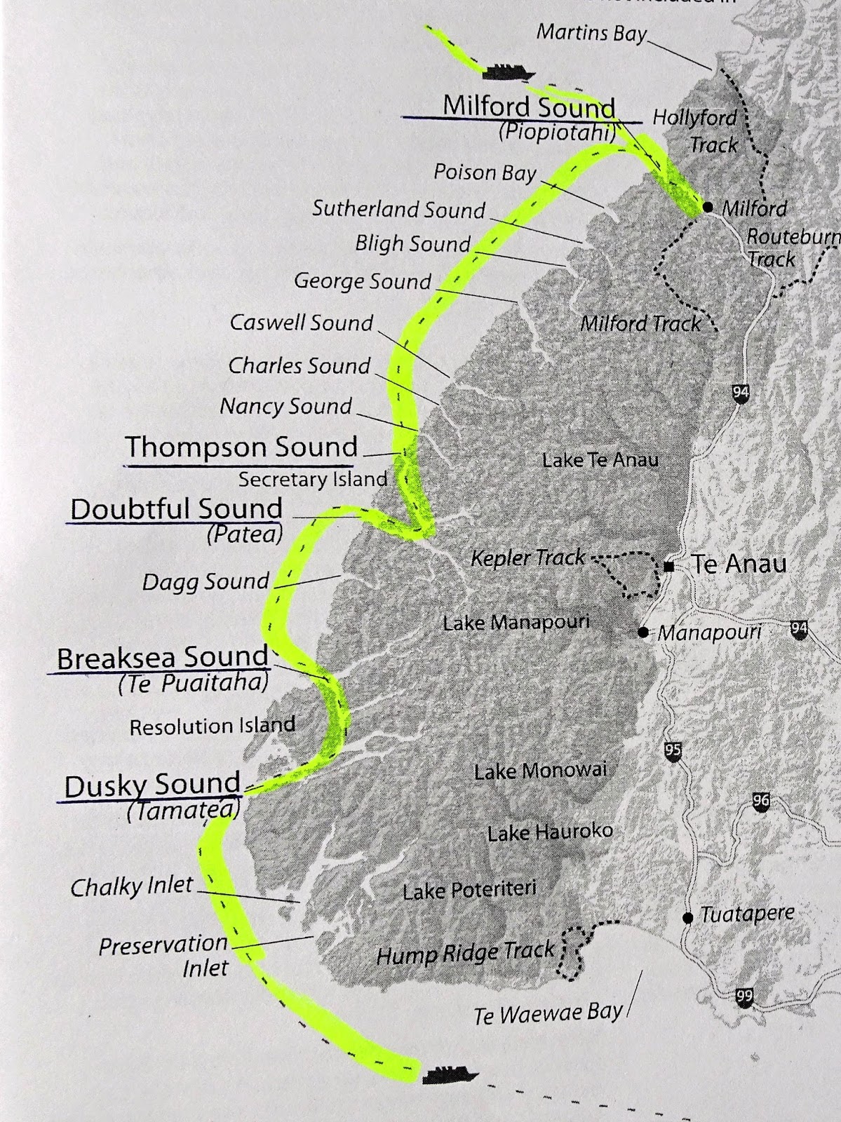
Highlights of our cruise through Milford Sound include steep cliffs on both sides of the fjord and, of course, several waterfalls cascading hundreds of feet into the deep black fjord. Milford Sound has two permanent waterfalls ─ Lady Bowen Falls and Stirling Falls. Naturally, after heavy rain, temporary waterfalls run down the steep-sided rock faces that line the fiord. Nearby Mitre Peak is nearly one mile in elevation.


This is a very remote spot for visitors, and our local guide told us that he best way to see both Breaksea Sound and Dusky Sound is via cruise ship. We didn’t reach Dusky Sound until about 5:00 p.m. We had several invitations and reservations tonight, so we didn’t have time to dedicate more time to looking at this fjord. To be honest, from our vantage point on a cruise ship moving swiftly along, the three fjords didn’t look much different from each other. We would need to spend more time here to discover the features of each fjord in more depth.
We can definitely say that Fiordland is remote, pristine, and unspoiled. Much of it is accessible for exploration only by boat or seaplane. We wish it had been sunnier for the visit, but at least it wasn’t raining.
We’ve recently attended two excellent stage shows in the Galaxy Lounge and an equally excellent “Magic Castle at Sea” show in the Avenue Saloon. The magic show featured Master Magician Chris Capehart, whom we had seen perform several years ago. It is a given with these professional magicians that they will totally fool us with unbelievable tricks, especially the sleight-of-hand skills that Mr. Capehart displays in close-up venues. But he also has a quick mind and comical sense of humor that we enjoy.
Then last night (Tue, Feb 20) was “A Night at the Pops” starring Australian piano sensation Bernard Walz. We had seen him perform a different show, “A Man & A Baby Grand” on Crystal Serenity less than a week ago. He played nearly non-stop for a full hour while the ship was experiencing very rough seas. The music of George Gershwin, Leonard Bernstein, and Scott Joplin that he played were just incredible. The more up-close, intimate setting of the Galaxy Lounge on Symphony, compared to Serenity, may have added to our appreciation for how fantastic Mr. Walz is on the piano.
Tomorrow we’re scheduled to visit Stewart Island, New Zealand.
Jim & Ginny
No comments:
Post a Comment