Pages

Tuesday, April 17, 2018

April 15-16, 2018 – Guayaquil, Ecuador

We arrived in Guayaquil, at 2° south of the Equator, early Sunday morning (Apr 15) and departed Monday afternoon (Apr 16) at 1:30pm. We were pleasantly surprised about how modern, clean, and pleasant the downtown area of this city seemed to be. It formerly had a reputation of being industrialized, unattractive and dirty. But, we didn’t see much of that. Maybe it helped that we arrived on Sunday, and there was little in the way of traffic. Even the industrial port where we’re docked was quiet on Sunday.

Guayaquil (pronounced “why-a-keel”) is Ecuador’s largest city and its main port; while Quito is the nation’s capital city, 272 miles away and uphill into the Andes. It’s difficult to pin down exact numbers, but consensus from several sources is that the population of Guayaquil is around 3.5 million residents, while Quito’s is “over 2.6 million.” Our tour guide told us that Guayaquil is the economic capital of Ecuador, and Quito is home of the government.

Guayaquil is only 12 feet above sea level and has two seasons – the wet season (January through April) is hot and humid with heavy rainfall, and the dry season (May through December) with clouds but very little rain. We were lucky to miss the rains this year. Being close to the equator, they have nearly an exact 12 hours of sun and 12 hours of darkness every day of the year.

Believe it or not, while in Guayaquil we’re actually docked on the western bank of the Guayas River, 40 miles away from the Pacific Ocean. The Guayas River is the most important river in South America that doesn’t flow eastbound into the Atlantic Ocean. Its source is on the slopes of the Andes and Chimborazo, Ecuador's highest volcano. Water then flows westbound to the Pacific. Its total length is 240 miles. Below Guayaquil, the river flows through a low-lying delta crowded with small islands (islets) before entering the Gulf of Guayaquil. That’s how we got here overnight, cruising on this wide river.

We took a short 3-hour panoramic tour of Guayaquil at 8:15 Sunday morning. We were in a very comfortable, air-conditioned bus and had an exceptionally good tour guide named Mafy. She was very knowledgeable and proud of her home town. Most of the tour was on the bus, although we got off twice along the way. As we’ve found in many locations around the world, the area around a port is the least attractive part of a city. It was the case here as well. But, soon enough, we left the port and got into the city itself. There are many beautiful green parks we drove by. Three that were notable to us were Parque el Centenario, Parque Bolivar, and La Rotonda.


Parque el Centenario is a very large park in the center of the city with quite a few bronze monuments. The largest was built to honor José Joaquín de Olmedo, a poet and the man who led the Ecuadorian independence movement from Spain here in Guayaquil in a mostly non-violent overthrow. Mafy told us the whole story, but the summary is that after a great deal of planning, on October 9, 1820, with only two men killed, a group of civilians led by Olmedo, overwhelmed the Spanish guards and arrested Spanish authorities who had been invited to a meeting. After that, Guayaquil declared independence from Spain, and Olmedo was named Civilian Chief. We didn’t get off the bus here, but we snapped one photo out of a window (see photo above). October 9 is a national holiday, and the main street of Guayaquil is “Avenida 9 de Octubre,” in memory of this amazing accomplishment.

Parque Bolivar is also known as “Iguana Park.” For some reason, this park is full of Land Igua­nas – 300 of them, according to Mafy. She said that this land was the Iguanas’ home before the park was installed, so they just stayed here. Anyway, the park has become a tourist attraction because of the iguanas. We got off the bus and had 15 minutes to wander around on our own.


Yes, there is a statue of Simón Bolivar on the square, as well as a large Catholic Cathedral:


We then rode a few blocks south, down to the river and drove along Malecón 2000 -- the pride of Guayaquil. Malecón 2000 is a very modern, lengthy promenade along the river containing monuments, playgrounds, sculptures, gardens, restaurants, flowering trees, a museum, a performance space, an IMAX movie theater, and a shopping mall, all this stretching for two miles along the bank of the Guayas River. Of course, there are many river views and shady benches along the way. This was all due to an extensive, and very successful, urban-renewal project, intended to reclaim the city’s waterfront for the everyday use of its citizens.

One of the features within Malecón 2000 is La Rotonda – a large, impressive semicircle-shaped monument that Mafy pointed out while we slowly rode by. The monument commemorates a famous meeting in Guayaquil on July 26, 1822, between the two South American liberators, Simón Bolivar and José de San Martin, where they apparently discussed and strategized about the independence of all Spanish South America. Jim wasn’t able to snap a photo here, but the monument is a beautiful tribute to this historic event.

Mafy then led our bus past several more interesting areas, including the airport, the gigantic central bus terminal, a soccer stadium, and a funny Capuchin Monkey statue in the middle of the highway. She pointed out Santa Ana Hill, Guayaquil's oldest neighborhood and one of its most iconic sights. Santa Ana is a hillside district, with brightly painted homes, cafes, bars and souvenir shops, and cobblestone streets. Cannons, at the top of the hill and aimed toward the river, were once used to protect Guayaquil from pirates. Mafy said they are still fired today during celebrations.


Last on the tour was a greatly appreciated rest stop at the top of a hill for snacks and restrooms at the Wyndham Hotel. Their site has wonderful views; from here we could see both Santa Ana Hill and the muddy Guayas River, which is two miles wide at this point. There were some water hyacinth plants floating along the river. Interestingly, Mafy told us that the river is tidal, and it switches direction every day. During high tide, the river goes left to right, and during low tide it goes right to left.

There are a lot of modern, tall buildings on this hill, include the hotel itself and an intriguing twisty building.


Monday, we stayed on the ship and relaxed, until Mozart Tea in the Palm Court at 3:30. We enjoyed watching all the activity in the port. There was no shortage of trucks moving cargo around. Here’s the view from our balcony, as well as our route (marked in orange) southbound back to the ocean this afternoon (as shown on our stateroom TV).


Leaving port and then the 4-hour cruise downriver to the ocean was picturesque. We almost felt like we were in a river boat, as the crew maneuvered around small islands and shallow water.


Final facts:
  • Ecuador is named after it’s location on the equator. Just outside of Quito is the “Middle of the World,” where you can stand with one foot in the northern hemisphere and the other in the southern hemisphere.
  • The official currency in Ecuador has been the US Dollar since the 1990s.
  • In the past there were many refugees from Colombia moving to Ecuador to escape the drug trafficking violence. That seems to have stopped, and now there are people leaving Venezuela due to their unstable economy, migrating into Ecuador.
  • Crystal Symphony had to time its departure based on tides, and also to time our upcoming reserved arrival schedule at the Panama Canal on Wednesday, April 18.
Jim & Ginny


Sunday, April 15, 2018

April 12-13, 2018 – Callao/Lima, Peru

Callao is the main seaport for Peru and the gateway to Lima, both by sea and by air. We arrived at Callao’s very busy commercial seaport this morning and docked among many cargo vessels – immediately to our left and right were an enormous container ship and an equally enormous automobile transport ship. One thing we learned during our visit is that one thing they really don’t need are ships bringing even more cars to Lima; they have way too many already.

Lima is the capital of Peru and its largest city. In fact, it’s a huge, crowded city. Our tour guide, Max, told us that Lima’s total metropolitan population (including Callao) is 11 million residents ─ the seventh largest in the Americas, and the fourth largest in Latin America. Of the 31 million people living in Peru, 35% of them live in the Lima metro area. One other pertinent fact ─ Lima is the world's second largest city built in the desert, after Cairo, Egypt.

Max explained that the city grew rapidly in the 1980's and 90’s due to migration from other regions of Peru, especially from the Andean highlands. These people, including Max’s own family, were running from the violence and killings of Shining Path and other communist terrorist groups in the highlands. They fled to Lima, seeking refuge and to find work. Many of these people became “squatters,” and they formed entire new settlements here similar to the “favelas” of Brazil. After all these years, many of them still live in these squatter settlements.

Our on-board destination lecturer and geography professor, Bob Aalberts, told us that 77% of Peruvians now live in urban areas, and 30% of them live in poverty. They are very ethnically diverse, with a large Amerindian population (close to 45% of the total population).

Lima was founded in 1535 by the Spanish conquistador Francisco Pizarro at a confluence of three rivers leading to the sea, and it was the seat of Spanish rule in South America for nearly 300 years. Peru obtained its independence from Spain in 1821. On previous visits to Lima, we visited the central city, where there are still many impressive examples of colonial architecture. This time, we remained outside the city center.

We greatly benefited from a private car and driver set up by our travel agency that is connected with the Signature Connection group. It was a difficult day of driving in this chaotic, massively over-crowded city, and our driver David did a magnificent job weaving through and between immense traffic jams. Our guide, Max, explained what we were seeing. He’s a real pro and had been a tour guide for 10 years in Lima; he also had excellent English language skills.

We traveled by car for about 1½ hours from Callao to the museum and archaeological complex of Pachacamac, located about 25 miles southeast of Lima’s city center in the Lurín River Valley. Max led us on a guided tour, first in the museum and then through the ruins of the numerous temples, pyramids, palaces and dwellings of pre-Hispanic times.

Max told us that the name Pachacamac, can be translated as ‘"The one who animates the world" and that most experts believe that this means that ancient people believe this was the god who controlled fire and earthquakes. In walking through the museum, we learned that this site had been a holy place for more than 1,500 years, with one culture supplanting another over time. Through the years, it was the most important religious site on the Peruvian coast in pre-Hispanic times, where thousands of pilgrims traveled from the farthest corners of ancient Peru.

The museum itself displays artifacts discovered at Pachacamac, including ceramics, textiles and religious pieces, along with charts displaying timelines and other information. As we walked through the museum, Max explained the history and importance of the exhibits. Archaeologists believe that Pachacamac occupation began around 200 AD. There were a series of occupants during the “Lima Culture,” the “Wari Culture,” and the “Ichma Culture.” Then the Incas arrived (around 1450 AD) and took over the site. They apparently modified existing structures to their needs and built new pyramids and temples, including the very large “Temple of the Sun” on the top of a hill, and the Acllahuasi ("House of the chosen women").


The Spanish conquerors (1532) plundered the site and destroyed idols. Everything was wiped out, and the great complex of Pachacamac was forgotten for centuries, until 1939 when excavations began at the site. Since 1980 many foundations and universities have contributed financial aid to invigorate investigations. Within the past five years, archaeologists found a 1,000-year-old tomb containing over 80 skeletons and mummies.

After spending a lot of time in the excellent museum, Max and David drove us from site to site through much of the very large complex (approximately 1,500 acres of land). Most of the buildings are just piles of rubble in the desert now, but archaeologists are working on some of the main temples to reveal more ancient features. However, at the rate they’re working on this, it may take hundreds of years to excavate everything at the site.


Near the Acllahuasi building, we jumped out of the car and walked around its surroundings. This was a residence for young maidens – maybe female priests or maybe concubines. There were 200 rooms and each maiden had their own room. It was built using the classic Inca architectural style, with a series of trapezoidal windows and the traditional Inca masonry. The large number of cranes shown in the background below is the site for three new museums near this site, intended to consolidate smaller facilities. The area will soon be a historical and cultural center.


Max said that on some tours they climb the switchback trail up to the top of the Temple of the Sun and enjoy the view over the Pacific Ocean. We didn’t do that today, since we had a specific time to appear at the next place on the itinerary. This was a most interesting stop for a history lesson on ancient Peruvian civilizations, about which we knew absolutely nothing.

We departed Pachacamac and drove on clogged main roads and a series of maneuvering through back roads and dirt paths through rundown neighborhoods to our next stop at the Los Ficus Casa Hacienda. We were beginning to think that our driver was lost, and then he drove through a set of two large, locked gates into a green ranch oasis in the desert. This is a private estate and horse farm that opens its doors to the public on special occasions. When we arrived, we discovered that we were among a very small group of people, including our friends Butch and Diane, so we essentially had a somewhat informal private tour. We were led around by our host Alexandra who spoke flawless English.

She started by showing us paddocks for some of their well-groomed Peruvian Paso horses. This particular breed is known for its smooth ride due to its “natural, four-beat, lateral gait.” Those are Alexandra’s exact words. We think that means that they take a high step with their front legs and walk with legs laterally — left hind, left front, right hind, right front (rather than diagonally). We met the horses up close in their stalls and were allowed to pet them. These horses have very nice living facilities, with lots of flowers on their building.


We then sat on chairs (in the shade) alongside a large green grass show area, for demonstrations on the various steps that are required to train the horses for contests. The show was great, with a running commentary.


This took quite some time, and then anyone who was interested was allowed to ride the horses twice around the show area. We declined that invitation, but our friend Butch did it, and he looked good in the saddle. However, we did venture out to visit with the four horses close up.


After the show they served us an excellent Peruvian lunch eaten outdoors under cover – very tasty.

Everything about our visit to Los Ficus Casa Hacienda was first class and very well done. This was a unique experience, and they treated us like we were visiting royalty. The experience was relaxing and enjoyable. The home and beautiful hacienda must be owned by a very dedicated horsing enthusiast, and the guides who work here were absolutely wonderful.

It was tough to join the real world outside the gate of the hacienda and the terrible traffic – so many cars, trucks and ‘tuk tuks’ (small, 3-wheeled taxi vehicles) on the road. By now it was rush hour and it was even slower than earlier in the day. We didn’t think that was possible, but it was. On the way back, we took a short drive through Miraflores, the home of large hotels, new restaurants and expensive stores. It was nice, except for the terrible traffic and lack of parking.

By the time we got back to the ship, it was after 5:00pm. The day, visiting two only places, took a full eight hours. It was a great tour managed by an excellent tour guide and a great itinerary.

After dinner, we went to a first-class Peruvian Folkloric show, featuring music and dances by a group of local performers. They were full of energy, and we enjoyed the show a lot.


Next stop will be in Ecuador.
Jim & Ginny


Friday, April 13, 2018

April 11, 2018 – General San Martin/Paracas, Peru

After one day at sea, we’ve cruised in an overall northwest direction along the South American coast to our first port in Peru -- General San Martin – for a visit to Paracas and the Ballestas Islands.

This port was named after General José de San Martin, Peru’s most revered historical figure. It was he who led an army across the Andes Mountains from Argentina. From what we’ve read, we understand that after liberating Chile, he organized a naval fleet which came ashore near where we are today. They marched into Lima, capturing the city and declaring independence from Spain for all of Peru in July of 1821.

Once again, we’re in dry, desert conditions, as it looks really desolate in and around the port. Almost all the surrounding area is protected as part of the large Paracas National Reserve, which we were told encompasses some 827,000 acres. Following is a picture taken of the local terrain from our balcony window. There’s a total lack of anything green around here --


For today, we signed up for a ship excursion called, “Bellestas Islands Motorboat Cruise.” When we were here five years ago, we went on the same excursion and had such good memories of that trip, that we wanted to do it again. We boarded a nice large, comfortable bus that took us to the small village of Paracas. There were four buses for our tour group, and each bus carried forty passengers. We walked to an attractive new docking area adjacent to the Hotel Liberator Paracas, where we boarded four 40-person, open-air speedboats. The islands are uninhabited and off-limits to visitors, but the speedboats were able to get us very close. Our friends Butch & Diane joined us on the trip.


On the boat ride out to the islands, they stopped so we could look at a large, mysterious candelabra-shaped petroglyph on the side of a cliff. These lines were scraped into the desert’s crust and have been there for perhaps thousands of years; nobody knows for sure why they’re there, but there are lots of theories.


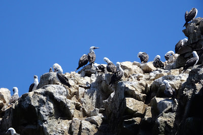
There are three adjacent Ballesta Islands that are collectively known as The Little Galapagos of Peru. We spent more than an hour circling the guano-covered islands, observing the wildlife. There were thousands of flamingos, pelicans, cormorants, Peruvian boobies, Humboldt penguins, and Inca terns. Our guide, said that there are 150 species of birds that are seen here. 


There were also more sea lions than you could possibly imagine. They seemed to like to crawl around and sleep on rocky spots or by the many caves and arches near the water line.


Most interesting was the “maternity beach” with hundreds of mothers and baby sea lions, with the babies crying out to their mothers plaintively.


We also enjoyed watching a mother sea lion teaching her baby to swim in the open water.


Our 30-minute drive, each way, to and from port, was through the Paracas National Reserve. There were many spectacular rolling hills, totally devoid of vegetation. There’s almost no rainfall here ever, except in an extremely unusual event. We were told that Paracas means “sandstorm” in the local language. In many ways, it looks like pictures of Mars that we’ve seen.


We were every glad to have taken the Ballestas Islands tour again, and it was a busy day snapping pictures.

Two of our world-cruise friends, Jim and Lois, took a different shore excursion today to see the famous Nazca Lines from a small plane. They reported that it was a great experience to see the ancient “geoglyphs” in the Nazca Desert from the air. The air was very clear and they were able to see everything perfectly. They said that the geoglyphs were bigger than expected, and they also enjoyed the museum which was co-located with the airport.

It’ll be a short cruise along the Peruvian coast tonight, as it isn’t far from our current location to our next in the busy port of Callao, Peru.

Jim & Ginny


Thursday, April 12, 2018

April 9, 2018 – Iquique, Chile

We’ve reached Iquique, in northern Chile, an area that was part of Peru until after the War of the Pacific. Iquique is an interesting location for many reasons, one of which is that it is located in one of the absolute driest places in the world, but it’s also a thriving tourist area for its beautiful Pacific Ocean beaches.

We went on an excellent shore excursion today called, “Ghost Town of Humberstone and Iquique Highlights.” We had a wonderful tour guide named Evelyn who kept us entertained and informed the whole time – she was a wealth of information.

First some important background information on local topography and climate. There are two tall mountain ranges that greatly affect climate here. The Chilean Coastal Range runs from north to south along the Pacific coast of Chile, parallel to the Andes Mountains. The Atacama Desert is located on the leeward side of the Coastal Range, which blocks moisture from the Pacific Ocean from reaching the desert from the west; while the Andes Mountains are so high that they block any clouds that could bring precipitation (from the Amazon Basin) from ever reaching the desert from the east. The cold Humboldt current and the semi-permanent South Pacific high-pressure ridge also are large factors in the dry climate.

The result is that Atacama is the driest hot desert on Earth. We understand that It rains about two millimeters (0.08 inches) a year in Iquique, but some weather stations in the Atacama have never received any rain.

The city of Iquique (population approximately 180,000) has the Pacific Ocean on one side of the city, and the coastal mountains on all other sides. The mountains are so tall that it looks like a very tall fortress wall surrounding the city. Upon leaving Iquique this morning, headed into the desert, we had to climb up and over a 2,500 ft. mountain almost immediately.


As we rode along for about an hour, Evelyn told us the history of Iquique and of the ghost town of Humberstone. The city and port of Iquique developed during the peak of the Sodium Nitrate (saltpeter) mining boom in the late 19th century. In 1872, James Humberstone, an Englishman, established a saltpeter mining company in the Atacama Desert about 30 miles east of Iquique. The company built a town named “La Palma” for industrial operations and as housing for the workers. Of course, at this time, national borders in this desert were unmarked and perhaps never established. Most of the mining companies that operated in the area were run by Chileans, backed by British investment.

Humberstone’s business grew quickly, and La Palma become a very busy town, with more than 3,000 people working in this hostile environment to mine and ship saltpeter, first via railroad to Iquique, and then for freighter transportation all over the world. At its peak, there were 3,700 people living here – workers, employees, and family members. For a while in the late 19th and early 20th centuries, almost all the saltpeter in the world came from the Atacama Desert. It was known as "white gold" and was in huge demand for use in fertilizers and explosives.

Eventually, there were disputes over taxation of profits from saltpeter mining, which directly led to the War of the Pacific (1879 – 1883). Chile won the war and annexed a large section of this nitrate-rich territory that Bolivia and Peru had claimed. We understand this is still a bone of contention even to this day, especially in Bolivia which lost its access to the Pacific Ocean.

During and after World War I, the British blockaded exports of saltpeter to Germany. That prompted the Germans to look for alternatives, and they invented synthetic substitutes that could be used to make fertilizer. Suddenly, no-one needed Chilean nitrate anymore. Production dropped dramatically, and employment fell. In 1959, the mines and plants at Humberstone shut down, and by 1960 the community was abandoned. The Chilean government renamed the town in honor of Humberstone, and it was declared to be a national monument. It was named as a UNESCO World Heritage Site in 2005.

We were amazed by what we saw in this ghost town. It looked like it had been a busy, lively community with a lot of activities for the residents. We thought there must be close to 100 buildings still standing, as if it was ready to fire up again at any minute. Evelyn gave us a guided tour of the town and told us that it was now being managed by a non-profit corporation of former children who had lived here with their parents. They want to preserve the town and are raising money through UNESCO and other sources to recreate what is part of their heritage.


No-one has lived or worked here for half a century. But in the dry desert air it apparently has been well-preserved. We visited the old company store where the workers bought their food and provisions, which has been set up as a nice museum. In the central town square, there is a tall town clock, a bandstand and large theater that must have provided residents with entertainment. Nearby are the remains of a hotel and restaurant, and even an old (empty) steel-lined swimming pool complete with diving board. We went in the four-room schoolhouse, still filled with wooden desks, as well as the old church building and the theater. 


After this most interesting visit, we returned to Iquique for a quick look at this city which appears to be booming again. Evelyn told us that this is partially due to the popular beach scene that has developed here, and the strong growth of copper mining, which is drawing businesses and workers to town. High-rise hotels and condos are springing up, especially along the Pacific coast. Our driver took us along the main avenue fronting the popular beach area of Cavancha, with big waves and a long, public walkway.


We stopped at the heart of town at Plaza Prat to do a little walking around. We spent a few minutes at a handicraft store and admired the 19th-century clock tower. One of the highlights of the day was a visit, including snacks and a Pisco Sour drink, at the “Centro Español” which was built in 1904 as a social and cultural center for the resident Spanish community. The interior of the building has tall ceilings, large paintings, and colorful tilework with a predominant Moorish flavor. Here we are with our Canadian world cruise friends Al & Karen.


In all, this was a great 5½-hour tour, which we enjoyed. We even learned some history lessons from this part of Chile. Now we’ll continue moving north in Peruvian waters and reach General San Martin, Peru on Wednesday, April 11th.

Jim & Ginny