Pages

Friday, March 16, 2018

March 16, 2018 – Bora Bora, Society Islands

Bora Bora was a disappointment today. Ever since we left the Cook Islands, we’ve been cruising with dark, cloudy skies and periods of heavy rain. There was some initial optimism this morning when Crystal Symphony cut through the reef opening at Bora Bora and dropped anchor in the bay opposite Vaitape, the island’s main settlement. The island was formed by volcanoes, and during some brief breaks in the clouds, we could see the two volcanic peaks – Mt. Pahia and the highest point, Mt. Otemanu (2,385 feet tall), jutting up in the center of the island.


For the next four days, we are scheduled to visit three of the islands in the Leeward group of the Society Islands – Bora Bora (1 day), Moorea (1 day), and Tahiti (2 days). They form part of French Polynesia, an overseas collective of France. The currency in use is the French Polyne­sian Franc.

We have visited these three islands three times each over the years, once on our honeymoon in 1974 and again in 2006 and 2013. On the honeymoon, we even bicycled all the way around Bora Bora (17 miles). For that reason, we had not made any shore excursion reservations for today. Our basic plan was to wait until about 11:00 to go ashore, wander around, and then find our own way to Bloody Mary’s, a well-known restaurant/bar not too far from the tender dock

Bora Bora is a rather small island, home to 8,000 people – a blend of Polynesian and Europe­ans, mostly French. The island is surrounded by a lagoon and coral reefs of the barrier type. We’ve read that the lagoon inside the coral reef at Bora Bora is three times as large as the land portion of the island.

The shore excursions scheduled to depart the ship by tender in early morning left to go ashore. But by about 10:00, the rain started up again, with strong winds and big waves. We were sitting down in the Crystal Cove reading our books when we heard that all further ship-sponsored shore excursions were canceled for today. We decided to wait until after lunch to make any further decisions on whether to go ashore in the rain.

Then it was announced that a high school group of local girls would be coming on board ship to do some Polynesian dancing at 2:15 in the Crystal Cove. We saw them up in the Trident Grill ordering 13 cheeseburgers and fries, followed by ice cream at the Scoops Ice Cream Bar. I guess that’s a favorite lunch even out here in the Central South Pacific. Their show was pleasant. It wasn’t a professional group; but, they were having fun, and our fellow passengers enjoyed it as well. Even Captain Larsen (Master of the Vessel) and Shane Morley (Cruise Director) joined in the dancing.


By then it was too late for us to go ashore. Maybe we’ll have better luck tomorrow in Moorea.

Last night we went to the Churrascaria (Brazilian) specialty restaurant for dinner. We’ve been to each of the four specialty restaurants twice since coming onboard Symphony a month ago. Our favorite is Prego (Italian), followed by Churrascaria (Brazilian), and then Silk (Chinese). Umi Uma (Japa­nese) is very popular on the ship, especially for Sushi, but we have trouble finding anything to order on the menu (other than Australian Wagyu Beef). Of course, most of the time we like to go to Waterside Restaurant (main dining room), which is also very good for dinner.

Jim & Ginny

Thursday, March 15, 2018

March 14, 2018 – Cook Islands

We had no advance notion of what to expect in the Cook Islands, so we are happy to report we had a very pleasant time during our 2-day visit.

A quick idea of what we learned -- The Cook Islands are part of the British Commonwealth and were named after Captain James Cook, who sighted them in 1770. History says that the islands became a British protectorate in 1888, to keep them from being absorbed into what is now called French Polynesia. By 1900, administrative control was trans­ferred to New Zealand and, in 1965, residents chose self-government in free asso­ciation with New Zealand. The Cook Islands are fully responsible for their own internal affairs, while New Zealand retains responsibility for external affairs and defense.

There are 15 islands making up this country located partway between Fiji and Tahiti in the Central South Pacific Ocean. The two largest islands are Rarotonga and Aitutaki, which were our port stops yesterday and today.

Tuesday, March 13, 2018 -- Rarotonga
We got lucky today, as the seas calmed down, and we were able to anchor offshore on the northern side of the island of Rarotonga and successfully take a tender boat ride into the small docking area at Avarua, capital city of the Cook Islands. As many experienced cruisers (includ­ing the two of us) can tell you, ships often miss port calls here due to rough/choppy water condi­tions. That wasn’t the case today. Admittedly, it was cloudy, with occasional light rain, but we still had a very good visit.


Rarotonga (population of approximately 11,000) is the most populous of the 15 Cook Islands. The island is ringed by sandy beaches, and the center (most unpopulated) is dominated by tall, lush green mountains, some of which rise up to 2,000 feet. Conditions here seem more prosperous than we’ve seen in the past few stops we’ve made. Rarotonga is a popular tourist destination.

When we reached shore, it was lightly raining, but we quickly found the minibus for our shore excursion, “Rarotonga Highlights & Cultural Performance.” We had an excellent tour guide named Kapi. He was born and raised on Rarotonga but then moved to New Zealand, as many Polynesian islanders do. When both of his parents died, he returned to Rarotonga because all land in the Cook Islands belongs to families. He was heir to the land, and he didn’t want it to leave his family. In this regard, it was also interesting that no land belongs to the government, and land cannot be sold to foreigners. For example, lands for the hospital, airport, and government buildings are all leased from the owning families. When the lease expires, it must be renegotiated. Cemeteries are owned by churches.

Kapi began the tour by driving on the “main road” that circles the island for its full 20-mile circumference. That’s a nice road, but he soon had the driver turn off this road onto what are called “inland roads.” Back off the main road is where most people live.


Everything on this island is green and many crops are growing – we saw bananas, papaya, mangos, tapioca, oranges, and noni being grown on small family-size plots. Here are some dragon-fruit plants.


We drove through an interesting area near the National Auditorium where each of the buildings is owned by a different one of the Cook Islands. When the people come to visit Rarotonga, they can stay in these houses, especially during national festivals.

After that, our first stop was at Ngatangilia Harbor, on the southern part of the island. Our guide told us that, according to oral traditions in the Cook Islands, Polynesian voyagers (Maori) left from this spot on Rarotonga around the year 1350 in giant canoes and settled in the new land they called Aotearoa (now called New Zealand). The story says that each canoe held 150 to 200 people, along with food, water, and animals. There are commemorative signs and plaques at this site, and periodic festivals are held. Interestingly, we have read that Rarotonga islanders are of the same Polynesian stock as the Maoris.

We made a lengthy stop at a large clubhouse for tasting many of the native Rarotonga fruits, followed by a cultural dance show, with five different-size hollow logs being used as drums to set the beat for a group of six dancers (4 guys and two girls). They did a lot of dances – very fast with a lot of shaking going on. We thought it was much like what we think of as Tahitian dancing, but Kapi said the Tahitians are copying the Cook Islands dancers.


On the way back to the tender port we drove past many resorts and hotels near Muri Beach, which has a large lagoon surrounded by a coral reef making it popular for swimming, snorkeling, and boating. Kapi said that 60% of all visitor accommodations are in this area; but, there are no private beaches on Rarotonga. Beaches are open and available for everyone.

Tourism is the Cook Island's main industry, and the biggest element of the economy. We drove by the large international airport, which was originally built by American military forces during World War II and then improved by New Zealand in 1974. There are frequent interisland flights as well as international flights to and from Papeete, Auckland, Sydney, and Los Angeles.

Wednesday, March 14, 2018 – Aitutaki, Cook Islands
Aitutaki is the second largest of the Cook Islands, after Rarotonga. The main feature of Aitutaki is a barrier reef surrounding a large blue turquois lagoon and the main island. The barrier reef is roughly the shape of an equilateral triangle with sides 7.5 miles in length. The southern edge of the triangle is almost totally below the surface of the ocean, and the eastern side is composed of a string of small islands called motu. Some people call this lagoon at Aitutaki the most beautiful of its type in the world, and we were lucky enough to see it today.


Crystal Symphony arrived early this morning (before 7:00 a.m.) outside the reef on the west side of the island, after a short 165-mile cruise from Rarotonga. There is a small break in the reef at this point, wide enough for one of our tender boats to pass through a narrow channel to a dock in the main village of Arutunga. On both sides of this channel we saw a lot of rocks poking up through the lagoon waters. The tender boat captains were very careful passing through here, and only one boat could pass through at a time, either one going in or one coming out.


Aitutaki Island itself is a low-key, laid-back place for approximately 2,000 residents. There are some tourist hotels and resorts, but they seem nonintrusive to the slow-paced nature of the island.

To get an idea of the topography, the total land area of Aitutaki Island is about seven square miles, and the area of the lagoon surrounding it is 29 square miles. Some of our fellow passengers with whom we talked went snorkeling today and raved about the shallow, warm turquoise waters, coral formations, tropical fish, and bright blue skies.

The two of us went on a 4-hour Crystal shore excursion today called “Aitutaki Acquaintance,” which required a tender boat ride through the break in the coral reef and the channel in the lagoon to Arutunga. That was uneventful. There were six small minibuses on the tour. Our driver-guide was chatty, but didn’t pass along much information of value. However, we did see a lot of scenery along the drive, which was quite rural. Houses were small, basic, and almost all were collecting rain water off their roofs, because the public water supply isn’t enough. Aitutaki is subdivided into eight villages, and we drove through most of them on our way around the island. Our first stop was at the oldest church – the Cook Islands Christian Church – founded by the first missionaries to arrive in 1821. 

We then stopped at a natural wonder – a giant Banyan tree in the village of Tautu Vaipae, that has grown above and over the road in a natural arch. We all hopped off the small minibus to snap photos. Next was a drive up to the second highest hill on the island for a look at the view. While here, one of the guides talked about how to put flowers in your hair, and what they mean. Then she sang a few songs with her ukulele. Another guide showed us how to husk a coconut (similar to what we saw on Tonga).


Last stop was at the Blue Lagoon Restaurant & Bar to admire the beautiful water in the lagoon and purchase refreshments, if we wanted some. We spent about an hour here.


We also stopped for a few minutes to look at the commercial airplane terminal, which was small and basic, for periodic inter-island hops – mostly to Rarotonga. But, inside the terminal were some interesting old photographs from World War II when American forces were stationed on the island, building the airstrip which is still in use today. The island was built to be the last point of defense in the Pacific, but the Japanese advance was stopped, and the island never saw action.

It was a good visit, but we felt that we just scratched the surface. Despite the large brilliant turquoise lagoon, 15 palm-covered motu (islets) to explore, and beautiful beaches, the island has been spared from mass tourism and it seems like a quiet place. It’s definitely not commercialized.

This was a “maiden call” for Crystal at Aitutaki – the first visit by Crystal to this site. We heard on the island that they average seeing a cruise ship here maybe nine times per year, and Symphony might be the largest cruise ship ever to come here. We had read in advance that Aitutaki is “The South Pacific's best kept secret.” We were glad to have seen this unique, picturesque tropical paradise setting.

Our next stop, in two days, will be another tropical paradise – Bora Bora in French Polynesia.

Jim & Ginny


Monday, March 12, 2018

March 11, 2018 – Alofi, Niue

Cruising in an easterly direction across the South Pacific, we reached the island of Niue this morning, a full day at sea after leaving Tonga. Yes, it’s true, it took us two days to reach here, even though the date changed by only one day. We left Tonga on the 10th, and today is the 11th. It happened because we crossed the International Dateline going eastbound; we’re back in the Western Hemisphere. The end result is that we experienced two separate Saturdays March 10th. This compensates for the day we lost when we crossed the International Date Line heading westbound last month. On that occasion, Tuesday, February 6th never existed for us.

If that isn’t confusing enough, it might also be difficult to find Niue on a map. As we sit here, anchored at Alofi, our coordinates are 19° 03’ South, 169° 55.81’ West. When it’s 10:00 a.m. here, it 4:00 p.m. back home in Florida, but at least we’re on the same date now.

Niue (pronounced “new-way”) is a small, single-island nation, with a total population of about 1,600 people. The town of Alofi (population: 434) is the administrative capital of Niue. Total area of the island, and the nation, is approximately 100 square miles (1.5 times the size of Washington, DC). Much of the island is flat, sitting atop 200-foot tall cliffs, with many caves at the base of the cliffs.


We were looking forward to today’s visit to this geographically isolated Polynesian island, but the timing was bad. People on this South Pacific island are very religious – 98% are Christian – and for them Sunday is very definitely a day of rest. All stores were closed, and there were no shore excursions offered. We also didn’t see any taxis in town or anyone offering island tours. 

Some quick background: The country of Niue is self-governing in free association with New Zealand. We read that New Zealand has responsibility for foreign affairs and defense, while Niue is fully responsible for their own domestic matters. This has been the case since 1974. Economically, Niue has understandable problems of a small population, few natural resources, and its geographic isolation. Apparently the sale of postage stamps to foreign collectors is an important source of revenue for them. The currency used in Niue is the New Zealand dollar.

Crystal Symphony anchored offshore from Alofi at 8:00 this morning. The two of us waited until a little after 11:00 a.m. to take the short tender boat ride onto the island, as we were told that the Visitor Information Center might open at 11:30. Sea conditions were calm, so getting onto and off of the tender was uneventful. The climb from the docking site on the island to the town was up a long, gradual hill. The heat and humidity made the climb even more tiring. However, we made it to the top safely. Ginny decided to sit in some shade while Jim explored town.


Alofi is a small town where one can walk through town in just a few minutes. Despite the fact everything in town was closed, the Visitor Information Center opened on time at 11:30 (after church). During Jim’s walk through town, the only local people he saw were the two people at the Visitor Center, and it was very crowded there with passengers from our ship. It’s too bad it was Sunday, as we would have liked to learn more about life here by talking to some of the residents. We also believe the town would benefit from a small infusion of money from our cruise ship passengers buying souvenirs or even visiting a cafe. Here’s a picture of the main street of town; there wasn’t much activity today!


Ginny was lucky enough to speak with a local lady who had just come out of church. She claimed that she didn’t know a cruise ship was going to be here today. When asked how many cruise ships stop at Nieu per year, she couldn’t think of any. We learned later that this is the first time a Crystal ship has ever stopped here.

Most of our passengers, including Jim, made it to the Visitor Information Center. They did have a few trinkets for sale – earrings, postcards, and stamps. A lot of people brought snorkeling equipment with them off the ship. A coral reef surrounds the island, so swimming and snorkeling seemed likely. Less than ¼-mile from the tender dock was a set of steep stairs leading down the cliff to “Utuko Beach.” Jim walked most of the way down to the “beach” and thought that it looked mostly rocky. The climb was fairly rigorous, especially climbing back up the cliff. We do think a fair number of passengers made the visit to Utuko. Other than that one site, we understand there are no other beaches on the island – a little unusual for a South Pacific island.

In all, this was an interesting visit. Niue might be what many people dream of as paradise – warm temperature year-round, a coral reef on your doorstep, no crowds, no lines, no traffic lights, and a slow pace of life. But there must be a downside, as we read that there has been a steady exodus of local people to New Zealand over recent years.

We saw two excellent shows in the Galaxy Lounge, each on Saturday, March 10th. The first March 10th (before crossing the date line) was “Imagine,” a show in complete darkness with LED lights that are computer controlled on the clothing worn by performers (Crystal singers and dancers). This was a totally new show from the one we have seen on Serenity many times. This one was equally great, and we loved it; although, because you sit so much closer to the stage on Symphony, it had a different impact. Maybe we’ll sit further from the stage if they do it on Symphony again.

The second March 10th (after crossing the date line) was Jonathan Hawkins, a very talented singer with a strong voice. He appeared on Serenity in the past, as part of the cast on cruises we’ve been on. But this year on the World Cruise, he has two roles. He is World Cruise Special Events Coordinator, and he is a solo performer on the big stage (Galaxy Lounge). This is the best show we’ve seen him do. He’s very talented in many vocal fields – standards, pops, opera ─ and this night was really great.

One evening we went to the Hollywood Theater and watched the new movie “Murder on the Orient Express” which, we thought, was better than the reviews we had seen of the film. This world cruise on Symphony they have shown many newly released films, including “Darkest Hour” and “The Shape of Water.”

Crystal Symphony is continuing eastbound. We are scheduled to reach Rarotonga, in the Cook Islands, on Tuesday, March 13.

Jim & Ginny

Sunday, March 11, 2018

March 10, 2018 – Nuku'alofa, Tonga

We ended our last post as we were leaving Fiji. Since then, we had a full day at sea and cruised through the tranquil and beautiful South Pacific in a southeasterly direction toward Tonga.

Last evening, we had a special treat as all 10 of us who made arrangements for this world cruise with travel agents who are part of the Signature Collection, gathered for dinner in the elegant Vintage Room on Deck 6 of Crystal Symphony. Our Signature on-board hosts consulted with Head Sommelier, Ilija Marojevic, and Executive Chef, Peter Degner, to select seven fine wines and exclusive food paired to complement these specific wines. We had a magnificent six-course dinner, which we enjoyed over a 3-hour period. This was truly a special evening. We’re thankful to Signature, and our travel agent, Preferred Travel of Naples, Florida for sponsoring this experience for us. Here is a copy of the menu:


We weren’t sure we would be able to visit Tonga after reading the news about all the damage inflicted by Tropical Cyclone Gita last month, as we were transiting the Pacific on Crystal Serenity, heading to Australia. But when we arrived in Nuku’alofa this morning, the people of Tonga seemed to have survived, and there was a happy greeting on the dock from the local police band, with music continuing all day. Just before sunset this evening, there was a dance team on the pier entertaining us.


The Kingdom of Tonga is one of the last absolute monarchies in the world. We were told that the royal line in Tonga goes back more than 300 years. This is a small country, with about 106,000 total residents living on some 170 relatively small islands; less than 50 of which are inhabited. Of that number about two-thirds (around 70,000) live on the main island, Tongatapu, including the Tongan capital of Nuku’alofa, where we are docked today. This is a flat island, not at all like the mountainous Fijian islands.

Our destination lecturer, Dr. Teri Sowell, said there is a long history of trade and travel between the three South Pacific lands of Tonga, Samoa, and Fiji, although there were also periods of warfare in the past. Despite their close proximity, we are back to Polynesia when we reach Tonga, as opposed to the Melanesians in Fiji. Tonga is located almost directly south of the Polynesians in Samoa by about 550 miles (“as the crow flies”) and southeast of Fiji by about 500 miles. English is widely spoken on Tonga. These are well-educated people, with a high literacy rate (said to be 99.4%). As we observed today, Tongans, both male and female, are big people on average– both in height and weight.

Captain James Cook, during his second voyage to the South Pacific, named Tonga the “Friendly Islands” and stayed here for more than two months. Dr. Sowell told us that Cook presented a gift to the Tonga ruler at that time of a tortoise (named Tu’i Malila) that lived for nearly two centuries, receiving the “royal treatment.” The tortoise passed away, of natural causes, in 1963.

We traveled today on a shore excursion to see the Tonga highlights. There were four rather old school buses for the large group from Symphony who wanted to take this tour. The buses were “air conditioned,” when the wind blew through the open windows. It was hot and humid, but we observed a big slice of life on Tongatapu Island and enjoyed the tour. Our guide’s name was Lalala, a local school teacher who, luckily, had the day off from school, since it was Saturday.

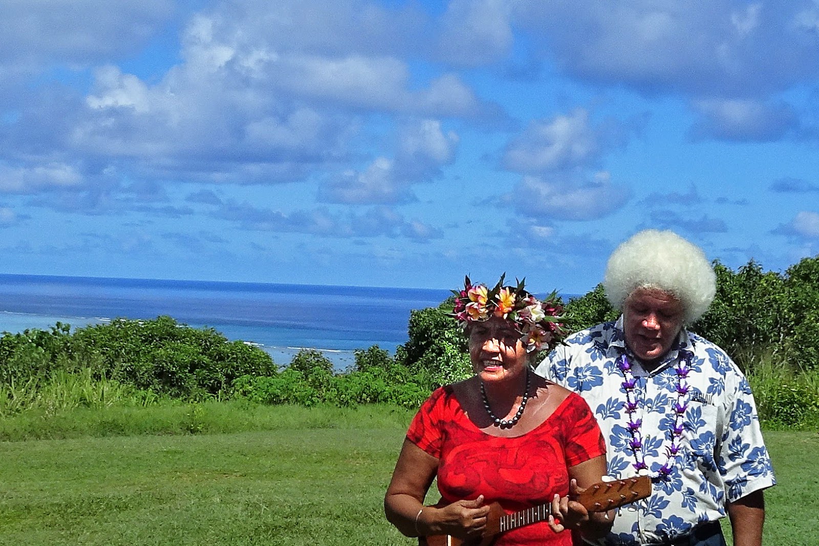
Our first stop lasted about one hour at “Ancient Tonga,” a cultural program staged by a group of happy, friendly Tongans. This wasn’t a big, slick stage show; it was a family affair. Their entire home site had been destroyed by the tropical cyclone last month, and they told us they built the fale (roofed open-air building where we watched their presentations) in the past three days. They started with a Kava Ceremony, of course, to welcome our large group to their home. Next were several dance numbers, which definitely were Polynesian but unique to Tonga. The ladies were wearing tapa cloth clothing; tapa is still seen as part of daily life in Tonga.


This was followed by demonstrations of husking coconuts, cooking with natural materials (coconut leaf, taro leaf, coconut milk, etc.) cooked in an underground oven, etc. Our guide told us that this cooking technique is still being followed today. Then were demonstrations of weaving with pandanis leaf, preparing tapa cloth, and the various protocols of wearing the unique clothing made from these materials.

Following this, we rode on our bus through the countryside to Captain Cook’s landing spot (from 250 years ago). Along the way, we saw some of the devastation from Tropical Cyclone Gita, all of which has not been cleaned up yet. Our guide told us the storm hit Tonga as a Category 5 hurricane. There was no electricity and no water for several weeks, and all the agricultural crops on this island were destroyed. Financial assistance, humanitarian supplies, and other aid from New Zealand, India, and Australia helped with recovery. From the moving bus, it was not possible to take good photos of the worst of the damage still remaining.


The nation’s Parliament House was totally leveled during the tropical cyclone. We saw the temporary home of the Parliament outside of town in what had been the Tongan National Cultural Center. A side note – just recently (2010), there were legislative reforms which led to Tonga’s first representative elections and a democratically elected Prime Minister. This is being viewed as a step toward becoming a functioning constitutional monarchy in Tonga.

After visiting Captain Cook’s Landing Site, we stopped to look at Ha’amonga – known as one of Polynesia’s most intriguing antiquities. The two vertical stones are about 16 ft tall, 14 ft wide, and 4.5 ft thick. The horizontal (lintel) stone is about 18 ft long, 4.5 ft wide, and 2.0 ft thick. There has been a lot of speculation as to the purpose of the Ha’amonga. 


According to an interpretive sign located here, the Ha’amonga was built somewhere around 1200AD. In 1967, the late King Taufa’afau Tupau IV stated that notches carved on the top lintel had some astronomical significance. This led surveyors to check, and they found that the notches do, in fact, mark the positions of the rising sun on the shortest and longest days of the year. As for now, that seems to be the local explanation for the purpose of this large, historic relic.

From here, we drove back to town and made two stops for picture taking. First was a graveyard for common people and then was the Langi (terraced tombs) of the Tongan kings. Note the amount of white sand used at the commoners’ graveyard. This is part of Tongan tradition. On the other hand, the Royal tombs mimic European graveyards. Commoners are forbidden to enter that graveyard, but it is visible through a fence.


A few of the many interesting things we learned during the tour – air conditioning is almost non-existent on this island. There is one large store (called CostLow) that has AC, and our guide told us that people like to go in there not just to shop, but to cool off occasionally. She told us that all of the commercial stores on the island are owned by foreigners (Chinese primarily), none by Tongans, although some Tongans do work in the stores. Any food, other than fish, roots, tubers, fruits and vegetables, must be imported – primarily from New Zealand, Australia, and the U.S. There are only three foreign embassies in Tonga – New Zealand, Australia, and China.

Tongans are very religious and very Christian. On Sundays, nobody works – all stores are closed, and radio/TV stations play only Christian programs. Our guide was a member of the LDS church (Mormon); but most people are Wesleyan (Methodist), although there are other denominations as well. She also said that every village has its own church. Many cars on the island are in terrible condition, maintained on a small budget.

The white-painted Royal Palace, visible from our ship, was built in 1867. The following photo was taken from our balcony. Our guide told us that the current King doesn't live there, because he doesn't need that much room in his house.


It was a good visit to this small South Pacific kingdom. These people are far-removed from stresses of modern life in most of the rest of the world.

On board Symphony, we continue to enjoy the entertainment selections. Most notably, recent performances by jazz pianist Kym Purling with variations on show tunes. He was a Vietnamese war orphan, adopted into Australia, and has gone on to great success – a wonderful, heart-warming story. We also attended one of the (near nightly) performances by the four members of the very talented Latin Dance Team resident on the ship. All four of them are from Hungary, and they are excellent multi-disciplinary dancers – youthful and energetic, to say the least. They also teach dance lessons to those who are interested.

Jim & Ginny


Thursday, March 8, 2018

March 8, 2018 – Yasawa-i-Rara, Fiji

Overnight, Crystal Symphony cruised slowly from Lautoka and anchored this morning about one mile off-shore from Yasawa-i-Rara, a small village on the long, thin Fijian island of Yasawa.

The Yasawas are a group of about 20 volcanic islands (six main islands and numerous smaller ones) forming the western border of Fiji. The group stretches for some 50 miles in a northeasterly direction from west of Lautoka. If you’ve ever heard of the Yasawa Islands, it might be because Turtle Island, one of these islands, was the site where both the 1949 and 1980 versions of the movie The Blue Lagoon were filmed.

Yasawa is the name of the main island of the Yasawa grouping, as well as the most northerly island of the group. It’s a long, skinny island, with a volcanic mountain range running along its length. Our visit today was to Yasawa-i-Rara, located at the northern end of Yasawa Island. We understand that the “i-Rara” suffix means “village of the chief.” Apparently the chief for all the Yasawa islands lives here. However, this is not a large village; we read that a total of only 200 people claim Yasawa-i-Rara as their home village.

Ginny stayed on the ship, while Jim traveled on one of the first tender boat rides in the morning onto the island. Seas were calm, so it was a pleasant ride from ship to shore, unlike a month ago when our visit on Crystal Serenity to Yasawa-i-Rara was cancelled because seas were too rough for safe tender boat operations.


This is probably what most people imagine when they think of a tropical island paradise ─ remote, unspoiled, picturesque ─ volcanic peaks, white sand beaches, palm trees, and coral reefs enclosing shark-free shallow crystal-clear water. Living here, the Fijian people have natural beauty, and there aren’t any stores, banks, or traffic jams. Most travel is done by canoe or motor boat on the water. Jim didn’t go in the water, but those who did go swimming or snorkeling told us the water was warm and pleasant.


Most of the passengers who went ashore started their visit by walking down a string of simple, small stands in front of homes along the shoreline. Local Fijian people were offering craft products for sale. During a passing rain shower, Jim took refuge under cover that one of the stands provided. While there, he purchased a couple of shell necklaces for Ginny, that he was hoping had been made locally. He then walked at least ½-mile along the beach, in the sand, before turning back to catch the next tender boat to the ship for lunch.


The environment on the island was isolated, colorful, and undeveloped (except for the large Crystal Symphony cruise ship looming offshore). There didn’t appear to be any farming, so maybe the land wasn’t fertile. Or. maybe the Fijian people live off the sea and don’t need to work on agriculture. Everyone seemed to greatly enjoy our stop here.

Entertainment and enrichment continue on Crystal Symphony. A highlight for us was Tim Campbell – a personable, energetic, and talented TV star/entertainer from Australia. He did a fun “rock and roll show,” on formal night a few days ago. The Galaxy Lounge audience was enthusiastically participating. We also attended a cooking show by John Ashton, a guest chef who demonstrated how to make chicken tacos and fish tacos from scratch. He was also entertaining with an excellent sense of humor. Richard Roth, a CNN senior correspondent also had an interesting presentation. He Joined CNN when it launched in 1980 and is currently covering the United Nations, still for CNN – 38 years in the news reporting business. Last, but not least, was Chocolate Tea in Palm Court one afternoon. We think there’s an afternoon tea there every day, but we’re frequently too busy to attend.

We have a sea day tomorrow, as we travel in a southeasterly direction toward Tonga.

Jim & Ginny


Wednesday, March 7, 2018

March 7, 2018 – Lautoka, Fiji

We reached Fiji Wednesday morning, March 7, after cruising NNE from northern New Zealand the past two full sea days. Water conditions have been smooth and pleasant.

We’re now at 17.5° South latitude. Here is what the sky looked like this morning, with a beautiful sunrise at our first stop ─ Lautoka.


We visited Fiji about a month ago during this same world cruise, when we were on Crystal Serenity headed for Sydney, Australia. On that occasion, we visited Suva, the capital and largest city. Lautoka is Fiji’s second-largest city (pop: 52,500) and is on the same island as Suva (Viti Levu), but on the opposite side of the island (about 75 miles away, as the crow flies). Viti Levu is the largest of the hundreds of islands that comprise the Republic of Fiji.

We took an unusual tour today that was titled, “Great Taste of Fiji.” This was a tour that we arranged through our travel agent before leaving home 45 days ago. On this adventure, we definitely got an insight into the real Fiji, not the resorts or big tourist hotels, that’s for sure. The two of us, plus six others from the ship met Kali (our guide) and our driver when we came down the gangway. Then we piled onto a minibus and headed out for the highlands, in the interior of the island. We quickly passed through Lautoka and the very large sugar mill (the largest employer in this part of Fiji). Only brown sugar and molasses are products of this mill. Soon we were out in the countryside, passing field after field of sugar cane.

We started a climb in the Sabeto Valley, along the Sabeto River. We turned onto a rocky, dirt road for most of our trip, crossed the river several times (through the water), and climbed up steep hills. We were deep in the forest when we passed a gold mining operation. After about an hour of rough driving, we finally reached Kali’s home village of Navilawa. This is a small, tranquil place, but quite beautiful, inside of an ancient, dormant volcanic crater. That, of course, meant we were surrounded by tall mountains. We saw only about 20 houses here, although he claimed there are 200 members of the village. Not all still live in the village full time.

Before doing anything, we had to be allowed entry by the village chief. First, we had to put on a sarong (a big square cloth wrapped around our waist and legs). Then we entered the community center, taking off our shoes and sitting on the floor with our chief (guest lecturer Dan Ravin was elected) sitting opposite the village chief. They exchanged greetings and then drank from the Kava Cup during a ceremony that is done for anyone entering the village, we were told. After acceptance, we all drank our share from the Kava Cup and told the chief who we were and where we came from. Kava is from a root that is pounded, dried, and then mixed with water during the ceremony. For many Fijians, Kava is a link to their ancestral past and is the nation's traditional and national drink. It may be a mild narcotic. But, who knows? It was the color of mud and doesn’t taste like any other drink we’ve ever had -- slightly bitter. It must be an acquired taste, but was a one-in-a-lifetime experience for us!


While lunch was being prepared, several of us walked around the village and observed the small Wesleyan Church, the Kindergarten, and we scrambled up a large rock for the best view in town. There is neither electricity nor running water is this village.


There was a large spread for lunch, including breadfruit, cassava (tapioca root), eggplant, several types of cooked taro leaves, and papaya. All of this was eaten cross-legged on the floor off a very short table.

After saying our goodbyes and thanking them for allowing us to visit their village, we started the harrowing drive back off the mountain. Our driver was the real hero on this adventure. We felt this was an authentic view of how many Fijians live -- it was a worthwhile trip. On top of everything else, the landscape was definitely very pretty.


Kali told us that the total population for Fiji (on all 126 inhabited islands) is approaching 900,000. Fifty-one percent of residents are native Fijians, who are Melanesian. The second largest group is Indo-Fijian – descendants of Indian contract laborers who were brought to the islands by the British colonial powers in the 19th century. He explained that there are two weather seasons -- dry in the Winter season (May through October), and cyclone season (November through April). He claimed that in Winter the coldest it gets is 10°C (50°F), and they harvest sugar cane in June (Winter).

We continue our visit to Fiji tomorrow at the remote island of Yasawa-i-Rara

Jim & Ginny

Monday, March 5, 2018

March 4, 2018 – Bay of Islands, New Zealand

Crystal Symphony anchored in the Bay of Islands this morning in a driving rainstorm which continued through most of the morning and early afternoon. The bay we entered is a natural harbor on the east coast at the far north end of the North Island of New Zealand. The bay was named, once again, by Captain James Cook (in 1769), and describes the 144 islands around which one must navigate in order to reach the end of the bay. This part of New Zealand is called the Northlands, stretching upwards from Auckland. We’re now a short drive of less than two hours from the northern-most point of land in the country.

The Bay of Islands was the first area in New Zealand to be settled by Europeans ─ the first missionaries arrived here in 1814. This was also the site where the Treaty of Waitangi was signed. We learned a lot more about these two parts of history during our tour this morning, called “Highlights – Bay of Islands,” which we booked through our travel agency before leaving home in January.

Since we were anchored offshore, it was necessary to take an uneventful and smooth tender boat ride to shore at Waitangi. We were thoroughly soaked with rain after going ashore, even though we had rain jackets and umbrellas. Our local tour guide, Jill, was waiting for us about 20 steps from the wharf. There were about 10 of us from Symphony on the tour, and we fit well in the small 15-seat minibus Jill was driving.

We remained in the minibus for much of the tour and didn’t take pictures due to the rain.

The village of Waitangi (population: 300) is known as the birthplace of New Zealand, where the Treaty of Waitangi was signed in 1840, between Queen Victoria’s representative and 500 Maori chiefs. The treaty agreed to the end of English - Maori warring, ensured the Maoris of their rights to their lands, and to New Zealand becoming part of the British Empire. Jill drove past the treaty grounds and the museum but didn’t stop. She told us there are many rivers coming out of the mountains into the river leading to the Haruru Falls near the treaty grounds. The river was flooding and we couldn’t drive in there.

We continued to the town of Kerikeri (population: 11,000). Jill lives here and told us there is a lot of wealth in this town because of all the retirees that move here from Auckland, England, and the U.S., bringing money with them. It looked like a pretty little town to us. Then we made a stop at Makana Chocolate Confectionery Store. They gave each of us a sample of one of their chocolates, and they were so good that most bought some to take home with us.

Still in Kerikeri, we went to see the first missionary house in New Zealand (built in 1822 and sometimes called the Kemp House). It is said to be New Zealand’s oldest wooden structure. The Stone Store (built between 1832 – 1836), next door to it, is said to be the oldest stone building in New Zealand. It was formerly a storehouse, but now houses a store selling old-fashioned household items. It is a very peaceful, serene, and picturesque site. The rain temporarily stopped for a few minutes, so Jim snapped a couple of photos.


So far, we were fairly close to the coast. We left the Kerikeri area and traveled inland, passing through the town of Kawakawa, near to where coal was discovered in 1864. There is no longer coal mining here, and the economy is now based on farming.

The town is most famous (locally) as the location of special public toilets designed and made by Austrian architect Friedensreich Hundertwasser. There’s also a vintage steam train that occasionally goes on tacks through the center of town. That wasn’t enough incentive for any of us to get out of the van, in the rain, to visit the famous toilets. So, Jill suggested a short stop at the Redwoods Restaurant for a snack. Jim had hot chocolate, Ginny had Ginger-Lemon Tea, and we split a thick slice of apricot bread.

After the relaxing break at the restaurant, we visited the Te Waimate Mission House, which was built in 1832 on behalf of the (Anglican) Church Missionary Society. We were told this is the second oldest standing building in New Zealand. After walking through the house, looking at the spartan furniture, we walked over to the nearby church and cemetery which are still in use today.

Last stop was at the nearby Kawiti Glow Worm Cave. A tour is provided by a Maori family who own the land. We had visited the Waitomo glow worm cave during a previous visit to New Zealand and decided to skip the dark, damp walking experience in this cave. The remaining people in the group reported that the “worms” here are bio-luminescent and appear on the ceilings of the cave in the pitch-black dark, about 20 feet over their heads. They seemed to enjoy it, but thought the walking path was slippery and it was very dark when the flashlights were turned off. After that, we returned to Waitangi for the tender boat ride back to the ship.

We enjoyed seeing the countryside along the way. It was hilly terrain and mostly farmland. Interestingly, they don’t raise sheep here, because it gets too hot for them in the summer. We did see a lot of cattle and horses grazing in the fields. Crops include kiwis, apricots, wine, and timber (to be shipped to China and Japan). Jill was an excellent guide, especially her honest remarks about living in the Northland of New Zealand. One interesting thing she said is that many of her friends in Kerikeri leave during the winter months (when tourist business is slow) and fly off to Europe or the U.S., for the warm northern hemisphere summer weather. They are called “swallows,” similar to the “snow birds” we see in Florida during winter months.

This port stop ended our time in New Zealand – visiting 11 different ports in 12 days (2 days in Auckland and 1½ days in Tauranga – including the first day in Fiordland (Doubtful, Dusky, and Milford Sounds). This full segment in New Zealand is what we were most looking forward to on this World Cruise, and it fulfilled all our expectations.

We’ve been so busy documenting all the sights we’ve seen in New Zealand ports that we haven’t talked about activities on board Crystal Symphony. Of course, there has been wonderful food, world-class entertainment every night, and too many other activities to mention. Here are some of the entertainment shows we’ve attended while in New Zealand:
  • Peter Cousens – marketed as Australia’s most prolific leading man in major musical productions. Sang numbers from major musical productions in which he has performed.
  • Neil Lockwood – former star of ELO (Electric Light Orchestra) Part 2. A hard-rock performer that had everybody’s blood pumping in overdrive.
  • Soul Mystique – “Transformation Artists” who specialize in quick costume changes while dancing.
  • Keith Scott – A great impressionist – cartoon characters, politicians, royalty, movie/TV stars, and famous singers. Great fun.
  • Joe Turner – Magic Castle at Sea Magician
  • Crystal Entertainment Team Production Shows – ‘Curtain Call”, “Speakeasy”, “Crystal in Motion”, “5, 6, 7, 8”, “Variety Showtime” with Jonathon Hawkins & Sarah Hayes, “Dance Production” featuring Lead Vocalists Julie Bell & James Burn. Jonathan Hawkins also did a solo show with the Crystal Show Band.
We’re currently heading to Fiji, and should arrive in Lautoka on Wednesday, March 7.

Jim & Ginny


Jim & Ginny