Pages

Thursday, April 26, 2018

April 23 - 26, 2018 – Aruba & St. Barts

Since leaving South America, we’ve been cruising to the east-northeast through the Lesser Antilles ─ a geographic term referring to all the small islands in the Caribbean Sea south of Puerto Rico. Most of the exciting part of the world cruise is over for us, so now we can just relax in the Caribbean at locations with which we’re already familiar. Crystal Symphony stopped first at the island of Aruba, and then at the island of St. Barts.

Monday, April 23, 2018 – Oranjestad, Aruba

Aruba is one of the three islands off the coast of South America labeled by geographers collectively as the Leeward Antilles; but, more popularly, we see them referred to as the "ABC Islands of Aruba, Bonaire, and Curaçao.” Aruba lies just 15 miles north of the coast of Vene­zuela, and is a flat island with no rivers. It was settled by the Netherlands in the 17th century and has been in Dutch hands ever since, except for a brief period during the Napoleonic Wars. Together with the Netherlands, the countries of Aruba, Curaçao and Sint Maarten form the Kingdom of the Netherlands. Citizens of these countries are all Dutch nationals.

Due to its location, Aruba is outside the Caribbean hurricane belt. It has a dry and sunny climate year-round and an arid, cactus-filled landscape, especially on the northeast coast of the island. But the tropical heat is moderated by near-constant trade winds off the ocean. This climate lures visitors to the island, as there is reliably warm, sunny weather. Aruba is a small island (only 69 square miles) but has a big population of around 105,000 people.

Oranjestad is the capital and largest city in Aruba. It was named to honor the Dutch Royal Family, which is known as the House of Orange. From our perspective, after visiting here twice in the past, the city consists primarily of hundreds of local stores where tourists can buy souvenirs along with government buildings and a few casinos as well. Along the main street, you’ll normally find droves of tourists walking around and shopping. To the best of our memory, that’s about it in Oranjestad.

During our previous travels, we enjoyed being here and have seen most of the highlights of the island – including cactus jungles, wind-sculpted divi-divi trees, the Ayo Rock formation, the natural bridge (both before and after it collapsed in 2005), the picturesque old (1910) lighthouse, as well as the beaches and big hotels on the southwest side of the island. We’ve also wandered through the tourist-oriented stores along the main street in Oranjestad and peeked in at the biggest casino (to get inside and out of the heat).

When Crystal Symphony cut through the reef surrounding Aruba and docked at Oranjestad at about noon today, we took photos in both directions from the fantail of the ship, recognized where we were, and decided to walk a little while, but not too far, ashore.


Even though it’s probably only a 10-minute walk to the most interesting shopping section of town, we made it only to the tourist shops in the terminal. Jim’s ankle has still been bothering him when he walks, and he didn’t want to risk making it any worse.

Wednesday & Thursday, April 25-26, 2018 – Gustavia, St. Barts

It was an early arrival Wednesday morning (Apr 25), about 7:00am. We’re anchored well outside the sheltered harbor of Gustavia, capital city of the island of Saint Barthélemy (abbreviated as St. Barts in English). From where we’re tendered, about all we can see from our balcony on the starboard side of the ship is this volcanic rock in the harbor. This is just a pretty scene; it’s not the main island of St. Barts.


St. Barts is one of 16 northern islands of the Lesser Antilles in the Eastern Caribbean, collectively called the Leeward Islands. It’s located about 15 miles southeast of St. Martin, which we could see occasionally in the distance.

We’ve visited St. Barts in the past and took a panoramic tour of the entire island on one of those trips. This not a big island. In fact, we’d call it a small island ─ only 9.7 sq. mi. in size, with a total population estimated at 7,200 full-time residents. Of that number, 2,300 live in the capital city of Gustavia, and the remainder live in small settlements scattered around the remainder of the island.

St. Barts was never one of the Caribbean’s sugar-producing islands; thus, they never developed an extensive slave trade. We’ve read that about 90% of the island’s inhabitants are still of European descent. The first French settlers arrived in 1648, and it remained in French hands until 1784, when France sold the island to Sweden, which renamed the largest town Gustavia, to honor their King. France repurchased the island and took back control in 1878. Architectural style is still influenced partially by the Swedish period.

These days, St. Barts is an “overseas collectivity” of France and is one of four territories in the northeastern Caribbean that comprise what’s called the French West Indies, along with Saint Martin, Guadeloupe, and Martinique. This means that they are French citizens and follow the same laws and regulations as the mainland of France. As well, they have a senator sitting in the French Senate. French is the native language of St. Barts, and the Euro is official currency. We learned about these “overseas collectivities” of France when we were in the South Pacific (New Caledonia and French Polynesia) last month on this world cruise.

The island’s terrain is volcanic and rocky, with steep hills and valleys, twisty roads, and somewhere around 15 beautiful, secluded sandy beaches. The weather is mostly sunny and dry year-round. Many people consider St. Barts to be the Caribbean's most beautiful island. Much of the pockets of population outside of Gustavia are clustered around small hotels or villas. From what we’ve read, there are only 25 hotels on the island, and most of these are boutique in style with 15 rooms or less. In addition, we were told there are hundreds of upscale villas for rent on the island. 

The language, cuisine, and culture are definitely French, and their tourist offerings are oriented to the upscale end of the market. We read that they record about 200,000 visitors per year in St. Barts ─ luxury hotels and villas host 70,000 visitors each year with another 130,000 arriving by boat (including many of these by large, seagoing yachts).  

Enough of the background, we decided that we didn’t need to sign up for a shore excursion either day we were in port. On Wednesday, we hopped on a tender boat at about 9:30 for the fairly lengthy trip to Gustavia, and Thursday we stayed on board ship. Departure from St. Barts was at 2:00pm Thursday afternoon. 

Gustavia is a pedestrian-friendly town, wrapped around three sides of the horseshoe-shaped harbor. The tender pier is located right in the center of town. From there, we walked on Rue de la Republique, Rue de la France, and Rue du Bond du Mer (basically walking part way around the harbor), admiring red-roof bungalows dotting the hillsides, the upscale shops, and the equally upscale yachts docked in town.


The town is small, quaint, and clean. Almost all the boutiques that we saw were offering French imports – fashions, perfumes, and some artwork. Quality was high ─ but so were the prices. We finally found a reasonably priced tourist shop and bought a refrigerator magnet (for about triple the average price we’ve been paying everywhere else on this voyage). We never could find the pâtisserie we wanted to visit, based on what we remembered from the last time we were here five years ago. We could have caught a taxi to one of the very nice beaches on St. Barts or taken a catamaran ride, but we decided to just look around the harbor area. We talked to some of our friends on the ship, and everyone did about the same walk that we did.

Symphony stayed overnight anchored Wednesday evening at St. Barts, and the tender boats were running until midnight. That gave everyone a chance to sample the famous, elegant French cuisine on the island if they were interested. We decided that our ship’s cuisine was good enough for us. We were, however, a little jealous that Crystal took about 200 travel agents (who have been traveling with us this segment of the world cruise) out to a swanky dinner party last night in town. That was a decision that didn’t sit well with many of the world-cruisers, since we weren’t invited.

The good news is that St. Barts appears to have made a strong recovery from the damage it sustained from last summer’s Hurricanes Irma and Maria. We saw no aftereffects in Gustavia; but, of course, we didn’t travel out into the countryside to look around.

St. Barts’ small island size, and its rugged terrain, limited fresh water resources, and the necessity to import almost all food products, must all make it unsuitable for mass-market tourism. It’s definitely a beautiful island with a relaxed, slow-paced lifestyle, making it attractive for a limited number of high-end travelers or yacht owners who can afford the high cost-of-living. This was quite a contrast with what we saw on all the other 20 islands we’ve visited on this world cruise. 

We now have two sea days before our next port of call in Key West, Florida – about 1,157 nautical miles (1,332 statute miles) away. Our route will take us north of Puerto Rico, Hispaniola (Dominican Republic/Haiti) and Cuba. We're nearing the end of the trip, so we have a lot of packing to do; we might not even get off the ship in Key West.

This likely will be the last posting we send out for this blog until we get home on April 30, do some unpacking, and catch up on anything of immediate importance at home. We will send out a posting to summarize the 2018 World Cruise, from our perspective, when we have a chance.

Jim & Ginny 


Tuesday, April 24, 2018

April 22, 2018 – Santa Marta, Colombia

Santa Marta is an important commercial port and tourist destination on Colombia’s north (Caribbean) coast. The city dates back to 1525, making it the oldest city in South America. We caught a good glimpse of downtown as we cruised in this morning. We learned that Santa Marta claims to have the world’s tallest coastal mountain range (18,700 feet) clearly visible from the city. They also have a nice sandy beach area fronting the bay, right in downtown, with several tall tourist hotels. Population of the city proper is about 500,000. But there are many more in the surrounding metropolitan area, extending out as far as El Rodadero beach that we visited during our tour today.


We’re docked in the very busy industrial port, where one of their primary exports must be coal. Even though it was Sunday, we saw them working all day emptying large trucks of coal and arranging it into giant piles. In fact, that’s about all we could see from our balcony. We asked our tour guide about the coal, and he said there are usually cargo ships where we’re docked almost every day, and they transport the coal to Europe and the United States.


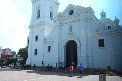
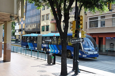
We left at 9:00 this morning on a fairly short, 3-hour Panoramic Santa Marta shore excursion. Our guide’s name was Guillermo. We began by driving through the city center in our very small, tightly packed bus. Highlights included the 17th century whitewashed cathedral and several jam-packed shopping streets. We believe the one below was called Fifth Avenue.


The beach here seemed nice and was starting to get crowded, even early on Sunday morning. Guillermo said that it would be full of local people later in the day. There were several hotels (including a Hilton Garden Inn that we drove by) and several high rises are under construction. There are a lot of Colombian tourists that come here for both the beach and the mountains. Santa Marta is the gateway for trips into the Tayrona National Natural Park, and for guided treks to the Lost City of Teyuna archaeological site, both in the mountains. There is also a gold museum here that might have also been the first house built in Santa Marta.

After leaving the city, we were very soon into rolling hills. Guillermo told us that it’s very hot in Santa Marta all the time, and they haven’t had any rain for seven months. We saw a lot of cactus plants -- everything looked very dry.


The tour then went down out of the hills and into El Rodadero, a busy tourist town, with a long, sandy beach along the Bay of Gaira, many hotels, restaurants, bars and other diversions. Once again, we had the impression that this beach area is mostly frequented by Colombians. It’s packed wall-to-wall with people in January and February, according to Guillermo. This wasn’t really on the itinerary, but it was worth seeing. We quickly left this town and returned to Santa Marta for a turn in a different direction to one of Latin America’s most revered sites, La Quinta de San Pedro Alejandrino.

This is the place where Simón Bolivar died in December 1830 and a highlight of our excursion today. The grounds are beautifully maintained – green grass and very large old trees. The hacienda originally dates back to 1608, when it was a working farm. Nearing the end of his life, the great “liberator” of five South American nations was not allowed to return to his native Venezuela, for political reasons. He fell fatally ill in Santa Marta and was taken to this hacienda for a few days, where he peacefully passed away (probably of tuberculosis) at the age of 47.

We took a leisurely stroll through the gardens and then to the hacienda building, which still has some of the original furniture including the deathbed and works of art. Guillermo took us room to room and explained what we were seeing.


 Next was a large white building erected for the centennial of Bolivar’s death (1930). In the center of this hall is a large statue of Bolivar. If you look at the statue from the extreme left and then extreme right, the statue seems to portray Bolivar as a young man and as an older man. It was quite hot today, so we were happy to return to the air-conditioned bus, observing iguanas as we walked along the trail.


This was a good, quick tour of Santa Marta. We learned a lot but were glad to get back to the ship in time for lunch.

There have been good entertainers the last few nights, two of whom were repeated from about a week ago when we had to miss their shows. This gave us a chance to see them. Broadway star and concert vocalist Christine Andreas, along with her husband Martin Silvestri were very good. She has been touring with a one-woman show, “Piaf, No Regrets” and did several of Edith Piaf’s best-known songs. Kieran Powell, a comical singing ventriloquist from England performed in the Starlite Club one night. Another singer, with whom we’re familiar, Lou Gazarra, starred in the Galaxy Lounge another night. He has added some very good music from when we’ve heard him sing before – it was very entertaining.

We now start heading north, with a few stops in the Caribbean, before returning home to Florida.

Jim & Ginny


Monday, April 23, 2018

April 21, 2018 – Cartagena, Colombia

It was a 280-nautical mile journey from Colón to Cartagena, and we arrived before 7:00 this morning. We couldn’t see much scenery from our balcony, as the view was blocked by the enormously large Holland America ship Eurodam. In fact, we were surrounded by cruise ships today. In addition to the Eurodam, there was Pullmantur’s Monarch and, later in the morning, Regent Seven Seas Mariner joined us. That’s a lot of tourists for one city to absorb.

Luckily, we had a tour of Cartagena with a private car and driver – the last one of the six set up by our travel agency and the Signature Connection group for this world cruise. We were able to go  to places in town that the large number of tour buses couldn’t fit into. Our driver Jose and tour guide Julio were great, modifying their itinerary and avoiding crowds as much as possible.

Cartagena has a long history, dating back to the first Spanish settlers in 1533, and it was part of Spain until declaring its independence in 1811. It retains much of the historic flavor in the “old town,” but today it’s also a big, modern city with a population near 1 million people. There are many modern office buildings, hotels, and towering condominiums – quite a contrast.

The tour was scheduled to start at 9:00, but we left the ship at 8:25, as we remembered what a long walk it is to the bus and cab pick-up point. Today, a Crystal shuttle bus took us part way, and then there’s a large shopping complex and bird aviary to navigate through. Once more, we were lucky, as we spotted our names on a sign that a local gal was holding. She greeted us and guided us through the maze of people and other distractions to where Julio was waiting. We actually got started early today.

We have been to Cartagena twice before and told Julio that we didn’t need to visit some of the most popular spots for visitors – for example, climbing to the top of the old fortress, seeing the Palace of the Inquisition, walking through old town, etc. That was fine with him. Julio told us he has worked as a tour guide in Cartagena for 39 years. Amazingly, almost everybody in town seemed to know him and called out to him by name. Not only that, but Julio & Jose work together often, and they seemed to anticipate what each other planned to do.

Cartagena is the city most visited by tourists in Colombia, and there is much to see. We started by driving out of the port and through the community of Manga which has fairly large, older homes, along with a lot of mango trees. Then it was off to the fortress Castillo de San Felipe de Barajas for a photo opportunity and to walk around a little at the base of San Lazaro Hill, where the fortress is located. The fortress was built in the mid-16th century and was the biggest and strongest fortification built by the Spaniards in the New World. Its purpose was to protect the gold and silver they were collecting before shipping it to Spain. There were always threats from pirates and other foreign powers. From what we understand, it successfully protected the Port of Cartagena for centuries. Every tourist that comes to Cartagena stops here, and many of them climb to the top for the nice view of the city and the port. It takes several hours, and we’ve done It before, so today we snapped photos and departed. Interestingly, Julio told us that the fortress was closed yesterday, because Hollywood was filming a movie there, starring Will Smith.


We went immediately afterwards to Convento de la Popa, for what is the best view of the city. In the second photo below, our ship is the small one, next to the two big Holland America and Pullmantur ships. The Regent ship (same size as Symphony) had not arrived yet.


The convent was built in the 17th century by Augustinian Monks, but there are only three monks remaining here, and they’re all in their 90’s. Julio says the population of Colombia is close to 50 million, and 90% of them are Catholic. He showed photos of Pope John Paul and Pope Benedict visiting this convent’s small wooden chapel. The monastery has a beautifully restored courtyard and an image of their Patron Saint, the Virgin of La Candelaria in the center of the altar. Once per year, she is removed from the altar and carried by a team of 40 men down the (very steep) hill, paraded around the city, and then brought back up the hill. We bought a magnet from a blind, one-legged vendor here. He, of course, is a friend of Julio.


Julio and Jose drove us all around Bocagrande (meaning “big mouth”), which is apparently also called “New Town.” This is definitely an upmarket neighborhood, containing the bulk of the city's tourist facilities, such as popular hotels (from 1-star all the way through 5-star), shops, restaurants, nightclubs, casinos, and art galleries. It is located between Cartagena Bay to the east and the Caribbean Sea to the west, featuring popular beaches on both the bay and the Caribbean sides of the community. On the bay side, there are many condos and a palm-lined promenade. We saw it all. The beaches looked crowded to us, but Julio said it gets more crowded on Sundays and during North American holiday periods. Upon leaving this area, we saw the large Bolivar Naval Base, which is also located in Bocagrande, facing the Bay.

Last on the itinerary was a short drive through historic “Old Town,” which is surrounded by the city wall. This is Cartagena's main attraction and its most crowded. Driving through here isn’t possible in a bus, as they aren’t allowed in this district of narrow streets and hordes of pedestrian tourists. Julio pointed out small stores and boutique hotels, along with churches, monasteries, plazas and unique architectural styles. On the way into “Old Town,” we had to pass through a hole in the town wall that circles the old city – nine miles in circumference. We were told that the wall was started in 1585, and it took 200 years to build and later rebuild due to destruction from raids by pirates and pillagers. At one point we had to take a detour off the planned route, as camera crews were setting up for more filming of the Will Smith movie.

We didn’t take any pictures in Bocagrande or in Old Town, as there was too much traffic and it wasn’t possible to park and walk around.

We then returned to the port and encountered a massive traffic jam of buses, taxis, and construction vehicles. It must have taken Jose 20 minutes to get us to the drop-off point. We think traffic is bad here every day, but with four ships in port, it must have reached capacity. We then wandered trough the bird aviary and large store before finding the shuttle bus back to Crystal Symphony.


It was a very good day, and we’re glad we had the private tour.

Jim & Ginny


Saturday, April 21, 2018

April 20, 2018 – Colón, Panama

We spent one full day (April 19) and two half days – the evening of Apr 18 & the morning of Apr 20 – in Colón. Yesterday, hundreds of Segment 5 passengers disembarked (left the ship to go home) in the morning, and hundreds of new Segment 6 passengers boarded the ship in the afternoon. It’s all done very quietly and orderly on Crystal Symphony. There are no announce­ments made over the loudspeaker system, and there are no mob scenes. If we didn’t know it was happening, we wouldn’t have noticed it except for seeing new faces around the ship.

Crystal Symphony had been docked at Pier 2, next to a large warehouse, which was ideal for handling suitcases and luggage yesterday. Overnight, the ship moved to Pier 1 which, in addition to being a cruise ship port, is also a shopping plaza with restaurants, a supermarket, and small shops selling duty-free merchandise. According to information we saw on the Internet, it is one of the best (and safest) places for foreigners to shop in Colón.

Unfortunately, Colón has developed a reputation as being unsafe, with a high crime rate. During our short visit, there have been labor disputes and demonstrations all around Colón. Local authorities warned Symphony passengers to take extra caution around the port area and downtown. We had signed up for a tour for yesterday, through our travel agent, but the tour was canceled at the last minute. We don’t know why; maybe it was because of the labor unrest. We decided to act on the side of caution and stayed on the ship all day yesterday. We relaxed, worked on paperwork, and finished writing the Panama Canal posting for our blog.

We signed up for a 3-hour ship excursion for today, out of town, to visit the Panama Canal Expansion Observation Center and portions of the former Canal Zone. It was a 30-minute ride on a comfortable, air-conditioned bus from the pier to the observation center.

Our very good tour guide was named Rosalba. She told us that Colón was founded in 1850 as the Atlantic terminal of a railroad that was then being built to meet the need for a fast route to California for the “Gold Rush.” At that time, it was a busy, prosperous place. Even during her lifetime, Colón had been a very nice town, and she’s very sad about how grim it looks today. Population soared during the building period for the canal, but now there is high unemployment in Colón. The city’s biggest employer today is “Colón Free Zone,” the second largest duty-free zone in the world, after Hong Kong. Goods from around the world are imported here, stored, and then exported. It’s almost exclusively for wholesale merchant shippers, selling in quantity.

Rosalba emphasized repeatedly that, after the opening of the Canal Zone, there was almost no contact between Panamanians and the deployed Americans who were operating the canal and the American military forces who were guarding it. There were 14 American army posts and air force bases built along the 50-mile length of the canal. GI’s and their families lived in virtual American cities on those bases.

To reach the observation center today, we drove through a jungle-like tropical rainforest, where we were on the lookout for sloths and wild monkeys. We stopped a few times to observe them in the trees. We arrived at the Agua Clara Visitor Center a few minutes before 10:00am. At precisely 10:00, an excellent movie began on the recent canal expansion.

Here’s a quick timeline, as described in the movie: The U.S. drew up plans for a third set of locks and started trenching work in 1939, but then World War II stopped the work completely. In 1977, the United States and Panama agreed on transfer of the canal to Panamanian hands. Panama took over administration of the canal on Dec. 31, 1999. Expansion of the canal was overwhelmingly approved by a public referendum vote in 2006, and construction of the “Third Set of Locks” was begun in 2007. The movie clearly showed the massive workforce, huge machinery, and complex construction required. One fact we remembered: the 192 thousand tons of steel required for the construction could be used to build 19 Eiffel Towers. Only two years late in finishing construction, the new locks at each end of the canal – Atlantic and Pacific – became operational in June 2016.

The expansion allows much larger ships to make the 50-mile trip from ocean to ocean. Previ­ously the maximum size of the ship that could make the passage, known in shipping circles as Panamax, was limited by the size of the Canal’s locks and the depth of water. Building the new locks allows for so-called neo-Panamax ships with a capacity nearly three times that of Panamax ships (14,000 standard shipping containers instead of just 5,000) to travel the Canal.

Of course, the highlight of our visit was walking to the outdoor viewing platforms and looking at the panoramic views of the gigantic cargo ships going through the new canal lock and into or out of Lake Gatun. You get a nice bird's eye view from 150 feet above.


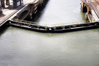
A big change at the new locks is that the old electric locomotives (called “mules”) don't keep ships centered in the lock. That work is now done by tugboats. Also note the lock’s gates don’t open like swinging gates. Rather, the “gates” slide sideways to let water flow into or out of the locks.


During our return trip to Colón, Rosalba guided us through several former U.S. military facilities on the Atlantic end of the canal, within what was U.S. territory -- the Panama Canal Zone (five miles on either side of the canal itself). One of these was Fort Gulick, a United States Army base which housed an airborne special forces group, as well as the “School of the Americas” – an initiative to train Latin American allies in military doctrine and tactics – now known as the “Western Hemisphere Institute for Security Cooperation.” In 1984, control of the fort was turned over to the Republic of Panama who renamed it Fuerte Espinar. Many of the facilities used by American forces and their families are still standing but were abandoned and never maintained or re-occupied. One section of the former base is now being used as the location for a hotel.


We drove through another former family housing area for American forces and canal workers, called “Margarita.” The area is now what Rosalba called “very high cost” homes for Panamani­ans. Some still look like they did 30 years ago, and many others have been spruced up. Both Margarita and the former Fort Gulick are now considered to be within Colón city's limits.

We returned to the ship at about 12:15pm, and Crystal Symphony left for Cartagena at 2:00pm.

Jim & Ginny

Thursday, April 19, 2018

April 18, 2018 – Transit the Panama Canal

We had two exciting milestones in our world cruise voyage yesterday and today.

Yesterday, Crystal Symphony crossed the equator northbound at approximately 4:00am. We were asleep then, so we didn’t notice the change. For the past 75 days (since early February), we’ve been cruising in the Southern Hemisphere (the South Pacific to be precise).

There was a King Neptune “right-of-passage ceremony” yesterday afternoon for those crossing the equator on board ship for the first time. They are now shellbacks, rather than their previous status as polliwogs. There were dozens of people kissing the fish this time. Even Captain Willheim got in on the action as well and jumped into the Seahorse Pool, along with the new shellbacks. We think he did it just for fun.

Today was our passage through the Panama Canal. We started at about 9:00am, and the weather was beautiful; this isn’t always the case in Panama. We’ve gone through the canal before, but it’s always exciting, as well as fascinating to watch. This time we entered the canal from the Pacific, near the port of Balboa, and we traveled in a northwesterly direction. We had a glimpse of Panama City through the morning haze.


Adding to the excitement today was seeing huge ships going into and out of the larger canal lane that became operational in June 2016 (see photo above). The new, larger lane parallels the old canal that we traveled on today. The canal expansion, and new lane of traffic, allows much larger ships to pass through. These ships, called “Neo Panamax,” are about 1½-times the size of the previous maximum size for the canal. As a result, these ships are now able to carry over twice as much cargo through the canal, avoiding the lengthy trip around South America and the Strait of Magellan. In addition to new, larger locks, they also widened and deepened existing channels and raised the maximum operating water level of Gatun Lake.

Back to Crystal Symphony, our “normal” size ship, as we travel through the old canal. The Panama Canal was originally built over a 10-year period and opened in 1914 (a little more than 100 years ago). Although there have been physical improvements over the years, the basic operation remains the same as when it opened. It currently handles over 13,000 ship transits per year (an average of 35 transits per day). We were told that Crystal paid over $200,000 for us to cruise through the canal today. Our destination lecturer told us that the canal collects over $2.5 billion per year in fees for passage. Transiting the canal is now possible 24 hours per day.

On each side of the Gatun Lake Divide, ships are raised and lowered 87 feet in a series of locks. There are three sets of locks (still original) for the canal. The 2-stop Miraflores locks and single-stop Pedro Miguel lock on the Pacific side of Gatun Lake and the three-stop Gatun locks on the Caribbean side of the lake.

After passing under the Bridge of the Americas (Pan America Highway), at sea level, we started in the Miraflores locks at about 10:00am, where we were raised 54 feet above sea level. Notice in the second photo below, there are two lanes of “traffic” at the lock. We’re headed for the left lane. After passing through this lock, we proceeded to the Pedro Miguel lock where we were raised up 33 feet higher. Each lock is 1,000 feet long and 110 feet wide.


Here’s the change in water level in the lock as we raised up (shown on the lock gate).


From there, we cruised for about three hours through the 9‑mile Culebra/Gaillard Cut ─ Continental Divide ─ (see below) and across the 23‑mile Gatun Lake.


On the Caribbean side of the lake, we were lowered, in a series of lock stops, a total of 87 feet back down to sea level, as seen on our stateroom television.


We exited the Panama Canal at about 5:30pm and turned to starboard headed for the port of Colón, where we will be docked.

Tonight, there was a private function, for full-world-cruise passengers only, at the Silk Restaurant on Deck 11. The event was called “Club Tropicana” and included cocktails (excellent White Sangria), 5-course dinner, and songs performed by the Entertainment Team’s singers and dancers, in-between courses of the dinner. The room was brightly decorated for the event, and all the entertainers were dressed like they were part of one of the old Cuban “hot” dance shows in Havana. Sarah Hayes, the World Cruise Hostess, was dressed like Carmen Miranda with a pile of fruits on top of her head and on her dress. The entire evening was planned and coordinated by Jonathon Hawkins, World Cruise Special Event Coordinator. Thanks go to Jonathon and Sarah, who are both busy entertainers in New York City, when they aren’t cruising with Crystal. Even Christine Andreas, an award-winning Broadway singer and dancer sang a number, along with her husband, Grammy-nominated arranger/composer Martin Silvestri who accompanied her on piano. The party was great fun.

We’ve stopped going to some of the evening entertainment shows being offered in the Galaxy Lounge, because there’s been so much repetition of the same production shows and the semi-permanent entertainers. They’re all good shows, but we don’t go to see the same show more than twice, unless it’s really special, and then we might go a third time.

All that being said, for this 13-day segment of the world cruise, we did see the following headline entertainers: Bob Arno, Pickpocket King; Salvatore Hasard, vocalist & multi-instrumentalist; and Martin Beaumont – British comedian.

Enrichment speakers this segment have been good: Prof. Bob Aalberts, destination lecturer; Dr. Bob Donaldson, world affairs lecturer: and Jon Malay, meteorologist, oceanographer, and space professional who spoke earlier on the world cruise -- praise to him, for preparing new materials.

Magic Castle at Sea remains a highlight with the Crystal world cruise. This segment, Magician John George had a great show. He is one of the best sleight-of-hand magicians anywhere and winner of many international competitions.

Of course, dining has been first class, as always on Crystal. Along with the Waterside (main dining room), we mix in visits to Prego (Italian), Silk (Chinese), Umi Uma (Japanese), and Churrascaria (Brazilian) specialty restaurants. Occasionally we invite friends to dine with us, and officers of the ship as well.

We have two more days in Colón, as we start Segment Six of World Cruise 2018.

Jim & Ginny


Tuesday, April 17, 2018

April 15-16, 2018 – Guayaquil, Ecuador

We arrived in Guayaquil, at 2° south of the Equator, early Sunday morning (Apr 15) and departed Monday afternoon (Apr 16) at 1:30pm. We were pleasantly surprised about how modern, clean, and pleasant the downtown area of this city seemed to be. It formerly had a reputation of being industrialized, unattractive and dirty. But, we didn’t see much of that. Maybe it helped that we arrived on Sunday, and there was little in the way of traffic. Even the industrial port where we’re docked was quiet on Sunday.

Guayaquil (pronounced “why-a-keel”) is Ecuador’s largest city and its main port; while Quito is the nation’s capital city, 272 miles away and uphill into the Andes. It’s difficult to pin down exact numbers, but consensus from several sources is that the population of Guayaquil is around 3.5 million residents, while Quito’s is “over 2.6 million.” Our tour guide told us that Guayaquil is the economic capital of Ecuador, and Quito is home of the government.

Guayaquil is only 12 feet above sea level and has two seasons – the wet season (January through April) is hot and humid with heavy rainfall, and the dry season (May through December) with clouds but very little rain. We were lucky to miss the rains this year. Being close to the equator, they have nearly an exact 12 hours of sun and 12 hours of darkness every day of the year.

Believe it or not, while in Guayaquil we’re actually docked on the western bank of the Guayas River, 40 miles away from the Pacific Ocean. The Guayas River is the most important river in South America that doesn’t flow eastbound into the Atlantic Ocean. Its source is on the slopes of the Andes and Chimborazo, Ecuador's highest volcano. Water then flows westbound to the Pacific. Its total length is 240 miles. Below Guayaquil, the river flows through a low-lying delta crowded with small islands (islets) before entering the Gulf of Guayaquil. That’s how we got here overnight, cruising on this wide river.

We took a short 3-hour panoramic tour of Guayaquil at 8:15 Sunday morning. We were in a very comfortable, air-conditioned bus and had an exceptionally good tour guide named Mafy. She was very knowledgeable and proud of her home town. Most of the tour was on the bus, although we got off twice along the way. As we’ve found in many locations around the world, the area around a port is the least attractive part of a city. It was the case here as well. But, soon enough, we left the port and got into the city itself. There are many beautiful green parks we drove by. Three that were notable to us were Parque el Centenario, Parque Bolivar, and La Rotonda.


Parque el Centenario is a very large park in the center of the city with quite a few bronze monuments. The largest was built to honor José Joaquín de Olmedo, a poet and the man who led the Ecuadorian independence movement from Spain here in Guayaquil in a mostly non-violent overthrow. Mafy told us the whole story, but the summary is that after a great deal of planning, on October 9, 1820, with only two men killed, a group of civilians led by Olmedo, overwhelmed the Spanish guards and arrested Spanish authorities who had been invited to a meeting. After that, Guayaquil declared independence from Spain, and Olmedo was named Civilian Chief. We didn’t get off the bus here, but we snapped one photo out of a window (see photo above). October 9 is a national holiday, and the main street of Guayaquil is “Avenida 9 de Octubre,” in memory of this amazing accomplishment.

Parque Bolivar is also known as “Iguana Park.” For some reason, this park is full of Land Igua­nas – 300 of them, according to Mafy. She said that this land was the Iguanas’ home before the park was installed, so they just stayed here. Anyway, the park has become a tourist attraction because of the iguanas. We got off the bus and had 15 minutes to wander around on our own.


Yes, there is a statue of Simón Bolivar on the square, as well as a large Catholic Cathedral:


We then rode a few blocks south, down to the river and drove along Malecón 2000 -- the pride of Guayaquil. Malecón 2000 is a very modern, lengthy promenade along the river containing monuments, playgrounds, sculptures, gardens, restaurants, flowering trees, a museum, a performance space, an IMAX movie theater, and a shopping mall, all this stretching for two miles along the bank of the Guayas River. Of course, there are many river views and shady benches along the way. This was all due to an extensive, and very successful, urban-renewal project, intended to reclaim the city’s waterfront for the everyday use of its citizens.

One of the features within Malecón 2000 is La Rotonda – a large, impressive semicircle-shaped monument that Mafy pointed out while we slowly rode by. The monument commemorates a famous meeting in Guayaquil on July 26, 1822, between the two South American liberators, Simón Bolivar and José de San Martin, where they apparently discussed and strategized about the independence of all Spanish South America. Jim wasn’t able to snap a photo here, but the monument is a beautiful tribute to this historic event.

Mafy then led our bus past several more interesting areas, including the airport, the gigantic central bus terminal, a soccer stadium, and a funny Capuchin Monkey statue in the middle of the highway. She pointed out Santa Ana Hill, Guayaquil's oldest neighborhood and one of its most iconic sights. Santa Ana is a hillside district, with brightly painted homes, cafes, bars and souvenir shops, and cobblestone streets. Cannons, at the top of the hill and aimed toward the river, were once used to protect Guayaquil from pirates. Mafy said they are still fired today during celebrations.


Last on the tour was a greatly appreciated rest stop at the top of a hill for snacks and restrooms at the Wyndham Hotel. Their site has wonderful views; from here we could see both Santa Ana Hill and the muddy Guayas River, which is two miles wide at this point. There were some water hyacinth plants floating along the river. Interestingly, Mafy told us that the river is tidal, and it switches direction every day. During high tide, the river goes left to right, and during low tide it goes right to left.

There are a lot of modern, tall buildings on this hill, include the hotel itself and an intriguing twisty building.


Monday, we stayed on the ship and relaxed, until Mozart Tea in the Palm Court at 3:30. We enjoyed watching all the activity in the port. There was no shortage of trucks moving cargo around. Here’s the view from our balcony, as well as our route (marked in orange) southbound back to the ocean this afternoon (as shown on our stateroom TV).


Leaving port and then the 4-hour cruise downriver to the ocean was picturesque. We almost felt like we were in a river boat, as the crew maneuvered around small islands and shallow water.


Final facts:
  • Ecuador is named after it’s location on the equator. Just outside of Quito is the “Middle of the World,” where you can stand with one foot in the northern hemisphere and the other in the southern hemisphere.
  • The official currency in Ecuador has been the US Dollar since the 1990s.
  • In the past there were many refugees from Colombia moving to Ecuador to escape the drug trafficking violence. That seems to have stopped, and now there are people leaving Venezuela due to their unstable economy, migrating into Ecuador.
  • Crystal Symphony had to time its departure based on tides, and also to time our upcoming reserved arrival schedule at the Panama Canal on Wednesday, April 18.
Jim & Ginny